This is the last of three series of a roadie trip down what is known as the Catlins, in Coastal Otago


An ecology initiative featuring nature’s wonders photographed, in southern New Zealand
This is the last of three series of a roadie trip down what is known as the Catlins, in Coastal Otago
Prior to this five day trip down the length of the coastline south of Dunedin known as the Catlins, my knowledge was limited to widely spaced out experiences such as an outdoor first aid course at the largest town Osaka, a school trip to a camp at Pounawea, a marvellous tramping and bushcraft training trip onto and along the Wapati Beach [at the end of which lurks the huge Cathedral caves, and we’d not had time to get to them], and much more recently assisting with road surveying at the southern end of the area in the vicinity of Curio Bay.
Well you may think that all the above words summarise “the Catlins”, but no, in-between is a wealth of interesting areas steeped in a history rich in seafaring endeavours, waterfalls, caves, timber milling and farming. Now days tourism especially in the summer “season” is a big thing though.
This “fill in the gaps”, scoping the flora and fauna trip for me bought up a lot of feelings I found fascinating. Maybe there is little outright poverty in this area that hosts something like a hundred or two rainy days a year, but under the hood of the vibrant summer tourism season, just getting underway there was evidence of a hand-to-mouth existence not easily found where I live in Wanaka.
As the trip unfolded it was great to see few tourism operations that exhibited a shallowness, and come across museums, cafes etc. and people that were real, what I call, Kiwi’ana.
The Cathedral Caves Walk is across Maori [Kāi Tahu descent] freehold land and is managed by a trust that charges is a small fee for the use of the car park and access to the bush track, beach and caves, during low tide only, in-between late October [spring tides may delay the opening a few weeks] and May..


Cathedral Caves are located in cliffs at the northern end of the Waipati Beach. Two sea-formed passages together measure just on 200 metres, with a height measuring up to 30 metres! Access is by a 1km walking track that descends through podocarp and kamahi coastal forest of the Waipati Beach Scenic Reserve. Upon reaching the beach, it’s a 10 minute walk to the Caves.

The walk to the caves was really enjoyable, but all too soon it was time drive further south…
Stinkhorn, and flies attracted the rotten meat smell emitted from this plallus shaped fungi…
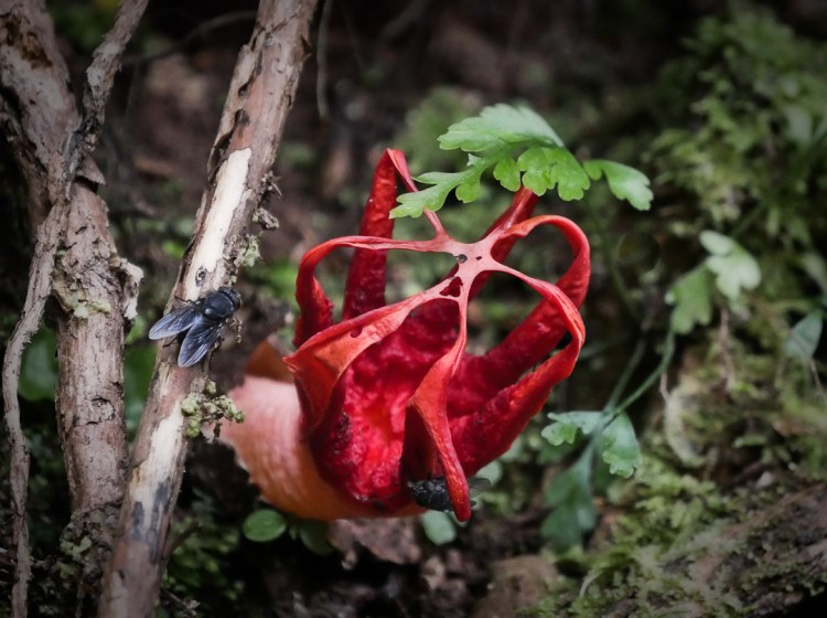
Maybe not good to meet if you’re in bare feet enjoying the beach…

I’ve never seen a spoonbill feed before and was rather amazed to observe them swinging their upper body through 180 degree while their beak is in the water – presumably it sort of sifts what passes through, or over the tongue…

Red bill gulls resting…

On the Mclean Falls track...

Mclean Falls…

Mclean Falls again…

One more article [#3 of 3] to come about this region – the images are prepared and I hope to write up 300 words + in the next week.
I’ve known for years that the cost and logistics of managing and eventually eliminating the introduced predators that are killing off our native bird species is not possible with trapping alone, and that even if it was we would not have enough people in New Zealand to do the job, man, woman and children included, yet many think we can.
Which gets pretty weird, but maybe this is because an estimated 80% percent of the population are urban dwellers. Then another factor is that 70% don’t think we have a problem!
Well we do! Here is one of the main culprits [by the way in less damp terrain the humble hedgehog is also, along with the stoat and feral cat, up there high on the list of the most efficient killers of birds].
This dead stoat was retrieved by myself high up on the track to Cascade Saddle in Mt Aspiring National Park after the application of 1080 in the West Matukituki Valley in 2014. The “find” was rated so useful by the Dept of Conservation that a 4wd vehicle was dispatched immediately on recipient of my radio call, and the body taken out to Wanaka and then sent off for a pathology report. Such is the detail sought after and attended to by DOC!

And so here we have below some mind boggling figures for trapping just a small portion of New Zealand’s native bird habitat – published today in response to a highly publicised statement by the Society for the Prevention of Cruelty to Animals:
The SPCA’s suggestion that trapping could replace toxins is totally naive. Let’s look at the logistics:The Department of Conservation is looking at treating 1 million hectares of conservation land with 1080 this year. To do just 250 hectares of trapping, targeting multiple species as 1080 does, you’d need to cut trap-lines 45km long, in grids through the forest. Let’s multiply that by just the conservation land in Northland alone. (116,000h/250h) * 45km = 21,000 km of trapline – which is enough to wrap halfway around the planet. Then you’d need 420,000 rat traps,
Read More at the Source: The SPCA’s anti-1080 policy isn’t just naive, it’s dangerous | The Spinoff
While composing the first of three posts [too many photos for one] on this southern Otago coast-line what comes to mind is shipwrecks! This, because of spending an hour or two in the museum at Owaka, and if I recall correctly there have been dozens of them [an on-line search will easily bring up the major 20 or so].
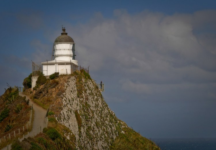
Never a truer word spoken – OK well, written on the well trodden path to the famous Nugget Point / Ka Tokata Lighthouse…

It’s hard to get just one lone tourist, but if patient…
Some of the rocks that are the bane of seafarers..

No place to be in the water! A gull, one of three species all endangered in NZ, makes play of the strong southerly pushing up the sea…

Dusk and mist settle on the Catlins River estuary…

Podocarp forest wind ravaged…

Sunset with sea mist…

Tides out..

I’ve never seen tui feeding on what lives on the seashore. It’s also one of the thinnest tui I’ve ever seen. Not sure if there is a lesson in this…

Wherever you wander in this area it’s wise to keep your eyes open, and when two lovers are spotted give them a wide birth of 20 meters or more. One of them is probably in pup, and at some point she’ll leave this bohemian setting and head inland into the podocarp forest to hide from the males – yes they can move surprisingly rapidly, and while there I saw one make quick work of scaling a vertical meter high bank…

Purakaunui Falls – likes millions before us, they have to be seen. Personally they were much smaller than I was expecting…

One more article to come about this region – the images are prepared and I hope to write up 300 words + in the next week.
Up until a couple off months ago I’d not done much in the way of New Zealand native bird photography for awhile, so wanting to visit relatives on the east coast starting from Timaru then proceeding through Oamaru to Dunedin and as I’ve done before I hatched a plan to visit favourite inland places that are quiet and lonely, such as the central lakes Ohau, Pukaki and Tekapo, where I could slowly walk or sit with my camera and wait.
Last time I visited the head of Lake Pukaki I had a marvellous time observing a number of endangered species including the black-fronted tern which live only in New Zealand – they feed on insects, lizards and small fish, and in this photo a few of them demonstrated their skill as low level aviators above the unique glacial blue waters of the Tasman River, which originates just upstream a little in Mt Cook National Park…

However on this trip that began in mid Nov. 2018, the weather changed the game plan – it was about as extreme as you ever get in New Zealand. Relatively speaking there was not a lot of damage fortunately but it played havoc with roads, notably in Central Otago where lots of rain over a short period of time is not the norm., thus as the vegetation is sparse there is no “blotter effect” to hold the water back from draining into rivers instantly, instead run-off is immediate and there-in lies the ingredients for overflowing rivers, landslips and general unusual doings.
In fact since then I’ve never seen our southern inland areas so green – Maniototo farm land..

I’ve posted pictures of the trip on a sister site:
Lake A A wild nor wester pipes down the valleys…
See more images at the source: Rogue weather for a roadie from Central Otago to the Mckenzie Basin and back again via Dunedin – Wanaka Images and Photography


