Wilderness verses Access, as it relates to Fiordland, and New Zealand’s largest landslide

At the end of March I headed off with a close photography friend to explore a small area of eastern Fiordland in the Lake Monowai and Green Lake areas.

En-route we met Fiordland artist Wayne Edgerton of Tuatapere, and enjoyed a hour or two with him discussing “light” and art from the perspective of painting and photography…
Artist Wayne Edgerton


Artist Wayne Edgerton


To get into the hills we utilised a road constructed in the 1960s to service two double circuit 220 kV power transmission lines designed to carry power from a Lake Manapouri based hydroelectric power generation scheme being constructed at the same time to supply power to an aluminium smelter being constructed at Tiwai Point near Bluff/Invercargill.

The facility is the largest electricity consumer in New Zealand, and uses approximately one third of the total electricity consumed in the South Island and 13% of the total electricity nationwide, equivalent to about 680,000 households apparently.

Construction of the power station and the road/pylon line attracted controversy for its environmental effects, and over 264,000 New Zealanders signing the Save Manapouri Petition when it was revealed the lake would be raised [and it never was thankfully].

In more recent times I know that many people have pondered that maybe NZ would have been better served to use this energy to build a stronger economy.  This line of thinking has probably not been helped by successive governments, keeping the pricing and deals secret.

Borland Road Power PylonsBorland Power Pylons


Dawn in Fiordland…
Dawn in Fiordland


Dawn and power pylons Fiordland National Park…Dawn and power pylons Fiordland National Park


Fiordland robin…
Fiordland robin


Grebe Valley, Fiordland…
Grebe Valley, Fiordland


To the left of this photo, looking towards Lake Monowai, is the toe of New Zealand’s [and maybe the world’s] largest landslide…
Grebe Valley, Fiordland

It is the largest documented terrestrial landslide in NZ, happening about 12,000–13,000 years ago. The slide is thought to have occurred when glaciers propping up the mountainside melted. With its support gone, a 9-kilometre section of the mountain collapsed into the valley floor 700 – 800 metres below.


This friendly 2 year old kea spent nearly an hour with me – great company…
Kea, Fiordland


Silver Beech forest edge revealed when trees were felled that might compromise the power lines
Silver Beech forest edge, Fiordland


Using an off shoot of the road to gain a good viewpoint…Borland power pylon


As night rolled in with mist on Mt Burns I got my favourite photo for the trip of a small lake above the Grebe Valley, taken from the point where the above mentioned landslide released…
Lake above Grebe Valley, Fiordland


For the whole 3 day trip I kept reflecting how we’d not be able to see and experience this taste of wilderness if it were not for the road, but on balance I think I’d rather know that there is more wilderness going forward, rather than less, as it’s too easily eroded away in the name of business/money.

The sun shines not on us but in us. The rivers flow not past, but through us. Thrilling, tingling, vibrating every fiber and cell of the substance of our bodies, making them glide and sing.

The trees wave and the flowers bloom in our bodies as well as our souls, and every bird song, wind song, and tremendous storm song of the rocks in the heart of the mountains is our song, our very own, and sings our love.

John Muir

The News Central Otago interviewed me recently

The News, Central Otago interviewed me a couple of weeks ago because of this web site initiative. The paper and article will hit the streets today apparently. I’m wondering how it’ll present!

Simon the interviewer steered me into aspects of my history in a very professional manner. Then sooner rather than later, since the web site was born of the experience, my more recent Matukituki Trust involvement was the subject I warmed to.

The noticeable decline of birds in the valley, kea especially, over the last 20 years was the background.

Reversing this has come about due to significant efforts from the Dept. of Conservation and the huge volunteer effort that has gone into the project with over 5500 hours already. Not to mention a truck load of money!

The morning chorus is now a reality up the valley – more birds of several critical species abound, and it’s something that has been a wonderful recent aspect of my 18 months up there over the last 3 years, and now we expect to see even more improvements.

The latest strategy has been the installation of the Hells Gate Virtual Trap Barrier which with the assistance of 9 volunteers was completed 4 weeks ago .

Hells Gate – where the West Matukituki gets squeezed by the ongoing uplift of the Southern Alps due to plate tectonics
Matukituki Hells gate

Mt Aspiring Station landowners, Randall and Alison Aspinall had generously agreed to the Trust installing a tight grid of traps between the bluffs and the Otago Boys High School Lodge, to prevent animals migrating up the valley. Otago Boys High School students have expressed an interest in being involved in the project, which is great too.

106 traps of various types were installed to form a barrier at the entrance to the Matukituki Valley [Hells Gates, is just upstream from Cameron Flat – see photos]. Aim being to stop the movement of predators up the valley – cut them off at the neck, being an entry way to Mt Aspiring National Park, so to speak!

The view up the valley…
Matukituki Hells gate

With Predator Free NZ 2050 looking to support large landscape predator projects, the Matukituki Valley [Trust)] is well positioned to be part of much larger projects too.

This is very much work in progress though – with massive scope/potential
.
Lastly, in the season ending May 2017, we’ve recorded 780 kills, including 95 stoats, 117 possums and 130 rats. For the first time we have encountered a number of cats, with 12 caught.

Below are some more photos of the area…
Matukituki Hells gate


Matukituki Hells gate


Matukituki Hells gate


Matukituki Hells gate


Matukituki Hells gate

Makarora Braided River – an under estimated biodiversity hotspot

Makarora braided river approaching the head of Lake Wanaka. BRaid (2017).

From the headwaters of the Makarora on the eastern flanks of the Southern Alps near the Haast Pass in Mt Aspiring National Park. The Makarora River flows south west and is joined by the Blue and the Young Rivers, then extending its braid plain further meeting its confluence with the Wilkin River before dissipating its energy into the head of Lake Wanaka.

Driving along the Wanaka Haast highway the Makarora braided river habitat is often overlooked or missed totally, yet the Makarora River is quite spectacular and is an important habitat for a number of important endemic New Zealand bird species and an array of other flora and fauna. A section of this captivating landscape can be seen in the video footage https://www.youtube.com/watch?v=g242GDSweiA produced by Braided River Aid (BRaid) on a frosty July morning. Braided rivers (defined by migrating, weaving channels of water between temporary islands of gravel) are iconic habitats unique to New Zealand encompassing an array of wildlife found nowhere else in the world.

There are a number of endemic bird species which depend on this habitat to complete their breeding cycle. During spring, braided river birds such as wrybill, black-fronted tern and black-billed gull can be seen returning to their breeding sites within the South Island.

The wrybill or ngutuparore is the only bird in the world that has a specialised bill which bends to the right, allowing it to feed beneath boulders and along the surface of the water on biofilm. This charismatic grey plover is nationally vulnerable relying on the unique braided river habitat to maintain its life cycle.


Adult wrybill nesting within braided riverbed (OSNZ courtesy of Dianne Parker).

Here the wrybill nests, lays eggs and rears chicks, its cryptic colouration blended effortlessly amongst the alluvial gravels of the riverbed. From January, onward wrybill flocks migrate north to their wintering grounds mainly in the Manakau and the Firth of Thames with smaller flocks elsewhere.

Juvenile wrybill at Miranda chenir shell bank (Firth of Thames) wintering site. Rachel Hufton

The black-fronted tern or tarapirohe, nationally endangered, is an attractive and highly distinctive bird in breeding plumage, slate grey contrasting with a black cap and bright orange bill and legs. Black-fronted terns also breed only on braided riverbeds of the eastern and southern South Island, from Marlborough to the Southland within small colonies and have now returned to Makarora. Their eggs and chicks are also well camouflaged against braided river gravels.


Black-fronted tern roost on a gravel island at Makarora. Rachel Hufton.

The black-billed gull or tarapuka is the most threatened gull species in the world. Though still relatively abundant, numbers of birds throughout the South Island have rapidly declined. The black-billed gull is more slender than the red-billed gull, with a longer bill and nests in colonies mainly on sparsely vegetated gravel riverbeds.


Black-billed gull colony on the Makarora braided river. Rachel Hufton.

Other braided river birds present on the Makarora include banded dotterel and South Island pied oystercatcher. The banded dotterel is the most common small plover of New Zealand coasts, estuaries and riverbeds but is nationally vulnerable. Banded dotterel breed within the braided river habitat but also use other habitats for nesting. Often seen running along the waters edge whilst foraging for invertebrates.

The South Island pied oystercatcher is the most abundant oystercatcher in New Zealand but is declining nationally. Pairs of South Island oystercatchers are often seen breeding in braided river beds but also within adjacent farmland. The conspicuous black and white plumage, distinct call and long red bill make this a familiar species.

Braided rivers are dynamic habitats, and as a result are threatened by a wide range of factors. These include habitat loss due to hydroelectricity development, weed encroachment of braided river breeding habitat, and recreational use of rivers. But the most significant impact is predation by introduced mammals.Black-fronted tern’s, wrybill’s and their nests are preyed on by rats, stoats, ferrets, ferral cats and hedgehogs. In addition, predation by southern black-backed gulls and Australasian swamp harriers, both of which have become more numerous following changes in landuse.

Considerable conservation management efforts have been made on some New Zealand braided river habitats, predominantly in the McKenzie Basin region and Canterbury which have positively contributed to braided river bird populations. This is evident in the Tasman Delta where Kaki black stilt have been reintroduced. A now rare species, once historically found throughout the South Island braided rivers.

The Makarora braided river requires collaborative effort to help restore, maintain and promote these specialised braided river birds to flourish for future generations worldwide. This can in part be achieved through advocacy and awareness raising. A recent braided river biodiversity and conservation workshop delivered at Makarora by a local ecologist, was a great way for students to connect with nature whilst learning about braided rivers.

Students and staff from Makarora located school camp following interactive workshop on braided river biodiversity, conservation and river safety (Andrew Shepherd).

Makarora braided river birds need help to successfully fledge their chicks this year without being subject to invasive mammalian predation from stoats, rats and hedgehogs. Any donations towards invasive mammalian trapping efforts on the Makarora braided river will be gratefully received by the threatened bird species that are beginning to nest. Donations or the sponsoring of traps can be made through the Southern Light website. With thanks.

Wrybill chick (OSNZ courtesy of Craig Mckenzie).


References

BRaid (2017) Drone video footage. Makarora and Wilkin River.

Hauer, RF. & Locke, H et al (2016). Gravel bed river floodplains are the ecological nexus of glaciated mountain landscapes. Applied Ecology. Vol 2, No 6.

nzbirdsonline.org.nz

Peat, N. Patrick, B Rebergen, A. (2016). Rivers Rare. The first 25 Years of Project River Recovery (1991 – 2016). Department of Conservation, Wellington, New Zealand.

Wittington, RJ. (2015). The foraging ecology of non-breeding wrybills (Anarhynchus frontalis) in the Firth of Thames: a thesis presented in part fulfilment of the requirements for the degree of Master of Science in Ecology at Massey University, Palmerston North, New Zealand.


Further information contact Ecologist: Rachel


A year in the life of the Matukituki Charitable Trust operating in Mt Aspiring National Park

The Matukituki Charitable Trust which operates in Mt Aspiring National Park has just released a newsletter which is reproduced below, [unless otherwise indicated photos and italicised text are by Donald Lousley who btw is proud to have been involved trapping, monitoring and making photos towards assisting with the great results as outlined below]:

Kia Ora

The Matukituki Charitable Trust (MCT) was established by Gillian and Derek Crombie in 2013 to ensure that the natural attributes in Mt Aspiring National Park’s Matukituki Valley are protected and enhanced. In partnership with New Zealand’s Dept. of Conservation (DOC), the Trust are now well on the way to restoring the habitat and increasing the population of all native flora and fauna with the long-term goal of translocating other species to this unique valley.

Matukituki charitable trust news 888

2016/17 Season West Matukituki Valley

MCT has successfully completed its busiest and most challenging year due to the dedication and determination of Paul Hellebrekers and our team of volunteers (more later). The team has completed the installation of 657 traps in the valley, implementing the first phase of the Trusts trap installation efforts. The traps have already shown their worth with a record number of 780 kills this season (end of May) and of real impact 95 stoats, 117 possums and 130 rats. For the first time we have encountered a number of cats with 12 caught. MCT plan to install 40 cat specific traps next year.

The Trust have also assisted DOC with rodent monitoring work, beech seed monitoring, and installing a rabbit proof fence near Cascade Hut – a great all-round effort.

The Trust has been very well supported by our volunteers and financial sponsors, showing that this effort to maintain and improve the valley does matter to people who are willing to give time, money and skills to make a difference.

We are winning and seeing great improvements in birdlife activity. With the current year being a beech mast event, we expect a real battle with predators in the spring and trust that DOC’s Battle for Our Birds campaign will be able to assist MCT work over this period.

Challenges and Triumphs

The year has been challenging in the valley with a semi beech mast event occurring last year but not enough to trigger an aerial predator control operation, so we have had to rely solely on the traps to reduce rodent numbers.

Matuki trust funnel
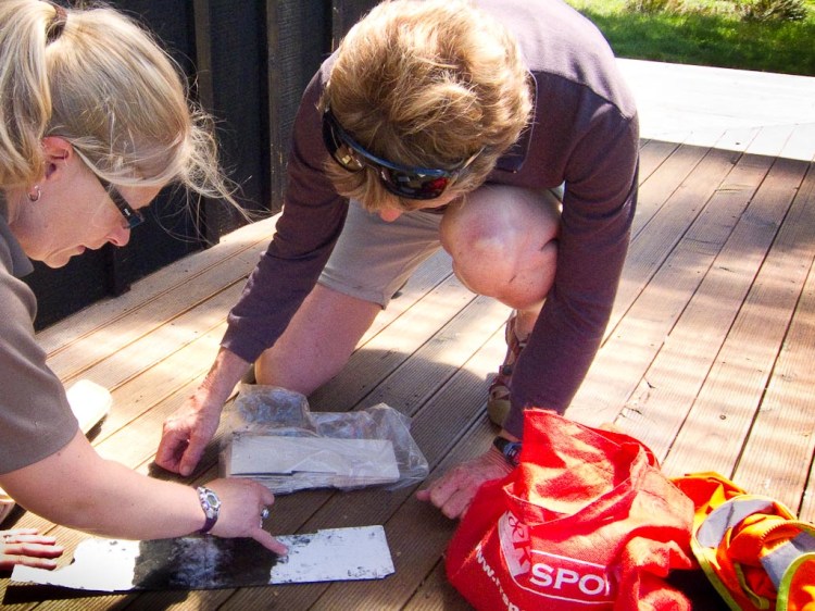
Beech seed funnel being installed to aid in the prediction of food amounts available to predators


To date birdlife has held up with a lot of anecdotal reports of good bird activity around the huts and tracks but fewer sightings of kea than a year or two ago. A few long term valley users reported that the morning chorus was amazingly better.

We are hoping that the trapping done over summer will allow a reasonable breeding season this year and avoid a population collapse. The high number of predator catches indicates a good breeding season for these species with the traps working and birdlife seems to be holding.

Over the last few years we have seen considerable increase in the numbers of South Island robin, kakariki and even a few kereru. This is very exciting for Heather and Stu Thorne who nurtured the small robin population which were translocated by DOC from the Dart Valley back in 2007 and 2008. Heather managed to catch and band 50 robins this year – a fantastic and patient result.

South Island robin in red beech forest
South island robin in red beech forest between Aspiring and Cascade huts


Overall birdlife is becoming more visible with confirmed sightings of kea, kaka, kakariki, bellbirds, kereru, native falcon, morepork, SI robin, fantail, tomtit, rifleman, rock wren, and Long Tail bats.

We are also noticing some strong regrowth in the undergrowth with the reduction in possum numbers. Overall the combination of poison and trapping has made a big improvement in the valley.

Paul’s contribution to designing and managing the work-plan is the primary reason that MCT have achieved its success and we are extremely fortunate to have Paul’s skills and knowledge.

Sponsors and Volunteers Support

The trust would not be able to achieve its progress without the help of our sponsors and volunteers.
This year we recognise the contribution from:

  • Southern Hemisphere Proving Grounds (Tom Elworthy) who have again financially supported Paul’s position as Operations Manager.
  • Tait Electronics (Garry Diack) who provided radios to improve field safety.
  • Stuart and Coleen Landsborough who funded the trap eggs for the season. Over 300 dozen eggs!
  • Longview Environmental Trust (John May) who sponsored this seasons Forest Bird survey and the use of their 4WD vehicle when required.
  • Aspiring Helicopters Ltd who provided assistance with high trap line access to keep the “old volunteers” mobile
  • DOC Community Fund (Formerly CCPF) who have largely funded the cost of traps and installation costs excluding volunteer time. 2017 is the final year of a funding grant approved 4 years ago.
  • DOC Wanaka for assistance with transport, expert advice and accommodation for volunteers.
  • Gillian and Derek Crombie provided general MCT funding.

Matukituki charitable trust tait 454
photo by MCT of Tait Electronics (Garry Diack in the centre) providing radios to Derek and Gillian

Also, a huge thank you for general donations received from those interested in supporting our project. Your donations help the Trust to positively focus on our vision

What has the Trust Achieved in 2017.
2016/17 Catches:

Matukituki charitable trust kill sheet 768
data by MCT


MCT are four years into a 5 to 10 year programme to restore the valley and so far we have a total of 657 traps installed including:

  • 142 DOC 250 single set Traps
  • 343 DOC 200 single set Traps
  • 5 DOC 200 Twin set
  • 33 Goodnature Possum Traps
  • 10 Goodnature Stoat Traps
  • 119 Trapinator Possum Traps
  • 5 Timms traps
  • 16 Beech Seed funnels
  • 80 Tracking tunnels

Matukituki charitable trust tracking tunnels
Examining predator tracks left in tracking tunnels


Expenditure

Over the last year MCT has provided $37,000 to fund the project and, in addition, volunteers have contributed 2,636.5 hours. Total funding to date for the project exceeds $140,000 and over 5000 volunteer hours plus considerable DOC hours in support. To maintain all the activities long term we are budgeting around $50,000 per year which will enable us to engage some assistance to check and maintain the trap network as well as extending some of the key trap lines that provide protections to kea and rock wren.

Kea on an electric fence
A kea, one of three now banded, on an electric fence – Cameron Flat, June 2017


Traps
The network of traps now extends on both sides of the river from Mt Aspiring Station homestead to the head of the West Matukituki at Scott’s Bivvy. Side trap lines include Otago Boys High School Lodge, Rob Roy Valley, French Ridge, Gloomy Gorge, Liverpool Track and above Cascade Track and Shotover Saddle route. The cost of traps purchased to date is almost $100,000.

Opossum in a Trapinator
One less predator caught in a Trapinator


Bird Monitoring

A big effort was made for the first time with bird monitoring. Three groups; Mainly Fauna (forest bird counts), Kea Conservation Trust (kea) and DOC (rock wren) carried out monitoring and banding programmes.

Matukituki Valley flock of kea
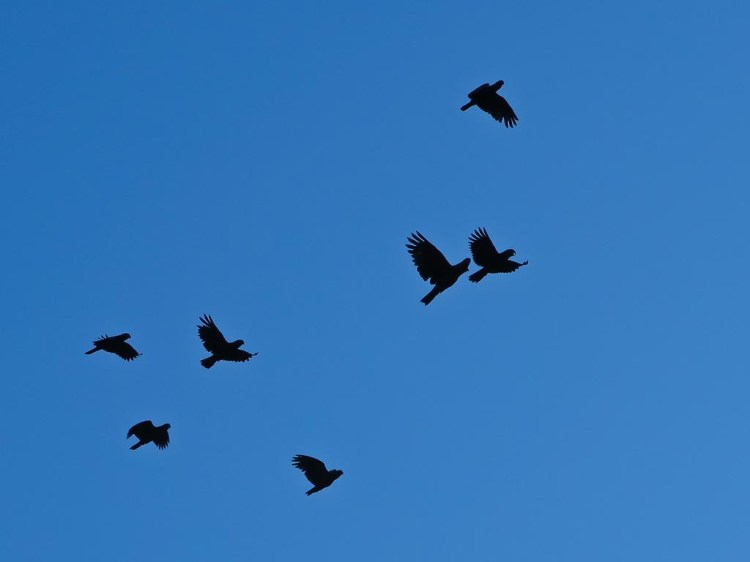
Matukituki Valley flock of kea above Aspiring Hut Feb 2017


DOC carried out a cat survey in May this year to determine the prevalence of feral cats in the valley. Low levels were recorded but control is recommended. Also, Patrick Stewart of Sound Counts brought a group of students from the North Island for the second year to monitor birds and long tailed bats with acoustic monitors. These surveys are the first so the results will be compared with the coming year to determine changes. Overall the survey indicated that bird numbers are fairly low. MCT are confident that there has been an increase compared to 5 years ago.

Mainly Fauna reported that estimated densities were high for rifleman (5.5 birds/ha), but considerably lower for bellbird, parakeet, robin and tomtit (≤1.1 birds/ha). Native species were encountered more frequently (54.0 birds/km) than introduced species (36.5 birds/km). Encounter rates were highest for chaffinch (Fringilla coelebs; 18.7 birds/km), followed by rifleman (17.2 birds/km), encounter rates for all other species were less than 8 birds per km.

NZ falcon
New Zealand falcon near Cascade Hut – March 2017


Anyone wanting copies of any of the monitoring reports referred to in the newsletter please contact MCT (matukitukicharitabletrust@gmail.com ) or Paul Hellebrekers.

Other Activities

As well as the active field work we have:

  • Held a well-supported Health and Safety induction course for volunteers
  • Continued our involvement in the Community Fund programme
  • Assisted other similar Trusts with resources
  • Played a key role in the wider Matukituki Catchment Animal Pest Control Project
  • Attended the Dunedin Conference- Inc – run by Yellow Eyed Penguin trust
  • Attended the inaugural Kea Conservation Trust conference at Arthurs Pass
  • Attended Predator Free NZ seminar in Queenstown

Matukituki Valley kea on a fence near a truck
Kea on a fence near DOC vehicle leaving Aspiring Hut


Partnership with DOC

MCT has continued its relationship with DOC Wanaka. Our thanks go to Mike Tubbs for DOC support and to the local team of Anita, Flo, Annette, Kerie and Dave for their practical support. MCT have nothing but full commitment from the Wanaka DOC team and this is a major factor in the continuing success of the programme.

Special recognition goes to Florence Gaud (Flo) who provides the technical expertise for the project and connects the various strands of work being done from trapping to monitoring to health and safety.

Volunteers -Hard Yards

The volunteer achievements of the Trust are credited to Paul Hellebrekers, Stu and Heather Thorne and Flo Gaud. This team have undertaken hundreds of hours work in the valley, much of it heavy lifting, cutting tracks and lugging traps through the forest. One new tough trap line was established through forest on the true left of the river, extensions to the Gloomy Gorge and ‘Wet Feet’ lines were also completed, along with replacing many of the older DOC traps. Trapinators have been added to most of the lower valley forest lines to target possum, with Goodnature A12 traps installed on some of the upper valley forested lines.

The Trust is fortunate to have a wide and capable pool of volunteers to the extent that we
seldom have a shortfall of people for work days.

Matuki trust heli
Aspiring Helicopters picking up volunteers


The teams generally fall into two groups: days trips to clear the lower valley traps – generally 4 or 5 people for a day a month, and overnight groups to install or clear the upper valley traps- usually 3 to 4 people. Anyone interested in joining the team are very welcome. MCT have work available for every level of fitness and experience from clearing traps alongside the road to high alpine traps requiring good back country experience.

Volunteers who have made it happen this season include:

  • Paul and Tess Hellebrekers
  • Stu and Heather Thorne
  • Gillian, Derek Crombie and the Crombie family
  • Rod MacLeod
  • Donald Lousley
  • John Hogg
  • Jane and Ian Turnbull
  • Murray Burns
  • Neil Sloan
  • Grant Morgan
  • Roger Brash
  • Henry Aubrey
  • Kris Vollebregt
  • Jane James
  • OBHS Students
  • Sandy and Stephen Mattingly
  • Roy Borgman
  • Randall and Alison Aspinall
  • Patrick Stewart (Bird and Bat Count Acoustics)

Mt Aspiring Station muster
Mt Aspiring Station muster – Randall and Sue Aspinal


Planning for 2017/18 season

We will be clearing the traps through the winter period where this is safe and from that we will get an indication of the number of predators present. The clearing of the traps will then ramp up again in spring. A recent Tracking Tunnel survey indicated very high levels of mice (100%) and rats (10.08%) over 16 tracking lines, so it looks like we will have a busy season ahead.

A significant project planned for in October, is the installation of 100 traps of various types to form a “Barrier” at the entrance to the valley near Hells Gates. Mt Aspiring Station landowners, Randall and Alison Aspinall have generously agreed to MCT installing a tight grid of traps between the bluffs and OBHS Lodge to prevent animals migrating up the valley. The traps will be placed at 50 metre spacing in several lines perpendicular to the river. Otago Boys High School students have expressed an interest in being involved in the project which is great.

Planning is also well underway to continue the monitoring programme (Kea, Rock Wren, Bats and forest birds) along with the monitoring of the current beech mast impacts.

MCT has engaged Mainly Fauna Ltd to carry out a repeat bird monitoring survey in the valley.

The Kea Conservation Trust obtained funding to research the kea population in the Matukituki Valley. This project has 3 main aims to support kea conservation initiatives:

  1. run an initial catch trip to enable attachment of transmitters and bands to adults and bands to fledglings and juveniles,
  2. monitor kea nest productivity and predator impact through the breeding season,
  3. run a kea survey and combine with all other data to provide a baseline for the local kea population. While their initial catch trip was thwarted by bad weather and had to be postponed until next spring, we support and encourage this work as it will help determine whether we are targeting predator control for kea as effectively as we can.

Join us in this quest for a unique valley experience.

The MCT Trustees and volunteers are ready for the coming season and looking with trepidation on the task of clearing and resetting over 700 traps up to the snow line. However, when we see the rewards of birdsong and activity and it all makes sense.

For further information on the Trust or the project please contact us:

Trust Website: http://www.mctrust.co.nz/ or email matukitukicharitabletrust@gmail.com
Or donate to: Matukituki Charitable Trust (Bank Account) 03-1594-0586292-000
Trustees: Gillian & Derek Crombie and Mark Pizey.


NZ falcon with a mouse
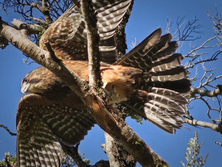
NZ falcon with a mouse by Aspiring Hut


NZ falcon landing in a tree
NZ falcon landing in a tree by Aspiring Hut


Matukituki Valley tomtit


Opossum
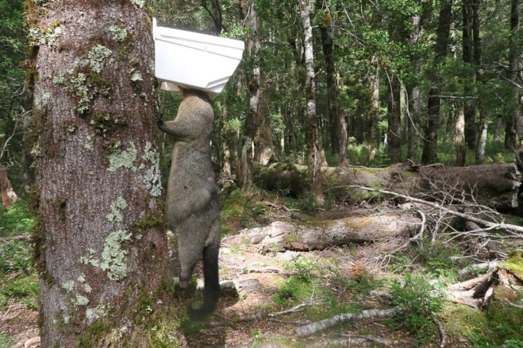
Opossum – one not caught, but encountered during trapping. The sore eye maybe the result of a scrap with another possum


South Island robin feeding
South Island robin feeding at Aspiring Hut


Matuki trust french 2
Looking across Gloomy Gorge from French Ridge Hut – some of the highest altitude areas The Trust traps.

How best to look after our precious New Zealand waterways – a personal view by Laurel Teirney of Wanaka

A personal view by by Laurel Teirney, a former manager at Ministry of Fisheries

The success of the community based/scientist/agency approach we adopted for looking after the whole of the Fiordland, and then the Kaikoura Marine Areas makes me feel we’ve struck on a “magic” formula that just might apply to our lakes and rivers as well.

My passion, at the moment, is finding out if such an approach might work for lovely Lake Wanaka – because I have watched in dismay as numerous lakes and rivers have deteriorated in front of my eyes. So something about our current approach isn’t working for our waterways.

Lake wanaka by laurel teirney
Lake Wanaka photo Laurel Teirney


There are those who say a combined community/scientist/agency approach will not work for this lake catchment – but why not give it a go? After all, what have we got to lose? And surely our lake deserves every effort to keep it in the low nutrient, high water quality category into the future for all our sakes!

buff weka
Buff weka family feeding in Lake Wanaka shallows in 2008. This species which had become extinct were once common on the eastern South Island. They were reintroduced from the Chatham Islands onto Lake Wanaka’s Stevenson Island and nurtured in an aviary before releases on Te Pekekara and Waikatipu islands and to Mou Waho Island in Lake Wanaka, where they currently enjoy surprising picnicking visitors.

Obviously a healthy lake is paramount not only for the well-being of these very special birds, but other species as well, notably ourselves!

To me the fundamental principles of the approach to managing the Fiordland Marine Area are likely to be the same for lakes – indeed for any type of waterbody.

1] First, the approach is all inclusive – that is, tangata whenua and every “interest” is represented and everyone selects their own representatives.

Cray fishing boat in Preservation Inlet NZ
Fishing boat in Preservation Inlet, Fiordland, with a cargo of cray “pots” [actually cages – lowered near rocks and pulled up again after a few days]. This is financially a high stress job, and dangerous. Also it’s a very different use of the environment compared to recreational fishing, and tourism

2] Then, when the representatives are around the table the first task is to agree on a shared vision. At our first Fiordland meeting in December 1995 there was a palpable sense of unease around the table. But when we went around the table and each person said how they wanted to see the Fiordland Marine Area in 20 years’ time, the unease was replaced by outright surprise – because everyone wanted the same thing!

Diving in Preservation Inlet, Fiordland NZ
A recreational diver in Preservation Inlet, Fiordland NZ. 2015. Diving for photos only due to it being a Marine Reserve, and as mentioned below not much is known about this area e.g. the fresh water layer here, on top of the salt water was approx. 5 meters, and nobody seemed to be aware of this – elsewhere it’s typically 1-2 meters

3] From then on, the primary focus stayed with the Fiordland Marine Area, not the desires of any participating group.

Marine reserves 3
Dusky Sound, Fiordland

4] Given the isolation of Fiordland little had been documented about the marine area – so the priority was to gather together what was known. Following the shared vision at the first meeting a large map of Fiordland was laid on the floor. Each group was given different coloured dots and asked to place them on the map according to the locations they valued. Red rock lobster and purple paua dots appeared rapidly all along the coastline. But the blue recreational dots were slower in coming – as we all know rec fishers are a bit reluctant to share info about where they fish…..but when they considered what might happen if they didn’t show their dots they too were around the map and the shared observations and experiences filled the room. Only then did Stewart Bull of the Oraka/Aparima runanga, calmly walk up to the map and place a single yellow Ngai Tahu dot way out in the ocean. Silence fell and then some-one asked “Hey Stu what were you doing way out there?” And he calmly replied, “Oh just looking around”. And that set the tone for the rest of the process – lots of good humour and camaraderie.

Dusky Sound, Fiordland National Park, New Zealand
Good humour is often evident in Fiordland, especially on the rare sunny day! A pessimist in Dusky Sound, Fiordland does therefore standout – near where Capt. Cook anchored up in Pickersgill Harbour for a month, after a circumnavigation up to three quarters of Antarctica.

One other experience of community knowledge that has stayed with me was the identification of the lines defining the inner fiords from the outer coast. I’ll never forget Pete Young, a blue cod and rock lobster fisher, standing at the maps marking exactly where those lines should be with input and encouragement from the rest of us. It wasn’t until several years later that Steve Wing, our marine scientist, produced data that simply reinforced the lines Pete had drawn.

Long Sound, Fiordland
No place to be in a 4 meter alloy tender with serious white water wanting to drive the bow under, and we’re upstream of a large rock, with all but 5 mm of it submerged – the head of Long Sound in Preservation Inlet, Fiordland

5] And so to the roles of the community and agencies involved. These were complementary right from the start and best described by an “egg analogy”. The yolk represents the community – all passion, commitment and knowledge about their place. The white represents the agencies – all support, advice and management tools for putting the management decisions in place. And there has been an additional benefit as the agencies now work in teams for every issue they deal with.

To me, this approach harnesses all the knowledge, all the passion and all the energy that leads to innovative solutions for even the most difficult issues.
And ongoing motivation is assured by the delight and reward of being involved in looking after one’s own place.

So my “dream” is to see many more of our waterways, be they lakes, rivers or marine areas looked after in such a way. Top of FormAnd logically, extending this from the mountains to the sea (ki uta ki tai), whole catchments could be managed in such a way – though the logistics are rather mind blowing I have to admit!

In the meantime though, I’m just going to continue advocating for a Lake Wanaka Community Management Plan.

Wanaka water purity
The depth of water under the boat at Mou Waho Island on Lake Wanaka is deep enough to engender a sense of vertigo, it’s so clear. So “clear” that maybe we take it for granted!

Sunset - Dusky Sound, Fiordland
Sunset – Dusky Sound, Fiordland, New Zealand

Unless stated otherwise all photo credits are Southern Light