Otago’s Aramoana Ecological Area – The Spit and Pilot’s Houses

A few months ago I was privileged to be appointed to the Otago Conservation Board. Such appointments are made by the Minister of Conservation. The first duty of a member is to work to achieve the statutory interests of the board.

Members are not representatives for any cause or organisation. Board meetings are public, and organisations can ask to be heard at them.

There are 15 Boards in NZ and each one is independent of any other body, and have a statutory obligation to represent the public interest in DOC’s work, and conservation in general within their region by advising DOC and the New Zealand Conservation Authority on planning and strategic direction.

A board can be requested by DOC to advise on issues like biodiversity, the use of public land, and concessions (a business may apply to use such land for their operations).

One of the first ones I became involved with was commenting on some old historic dwelling in the Aramoana Spit near Dunedin. In this case the owners of the houses have applied for a concession for them to stay on Conservation Land. They were built maybe 80 years ago, predating not only DOC, but goodness what other land designation.

Some field trip notes and images

Aramoana Spit, Otago NZ
The view along the spit – north is to the left. The 4 dwellings are at the far end, 3 of under the large trees. Note that 40 years ago the dunes were further to the left – right up to the tide line in fact. This is also the most popular beach for locals swimming.

Aramoana Spit, Otago NZ. Salt Flats
On the other side of the dunes, to the south towards Dunedin, there are very extensive salt mudflats.

Access to Aramoana Spit
The locked access road to the dwellings sidles along the south side of the dunes, with the very extensive salt mud flats on the right. It seems perfectly placed to not interfere with the local wildlife, which at the moment consists of sea lions in the dunes near the houses, and not penguins. Perhaps they’re not compatible?
Aramoana Spit, Otago NZ
There are a few gullies through the dunes that lead to the beach from the access road. Yes, those are dog prints.

Rainbow Tairoa Head from Aramoana Spit, Otago NZ
Great views of Tairoa Heads. The first dwelling on the extreme right – the 3 far more substantial houses are under the trees…

Bach, Aramoana Spit, Otago NZ
I loved the kiwiana style, and btw this is not one of the pilot’s houses. At this point there is an imaginary line between dunes and sea lion habitat to the photographers right, while at the left starts a different vegetation zone comprised of seemingly of a bit less sand.

Pilot's House, Aramoana Spit, Otago NZ
The second pilot’s house really close by, with path to the beach…

Shed and garage, Pilot's House, Aramoana Spit, Otago NZ
More kiwana

View south from Pilot's House, Aramoana Spit, Otago NZ
At this point the environment to the south, towards Dunedin is no longer salt marsh

Roof with lichen, Pilot's House, Aramoana Spit, Otago NZ
This roof faces the sunny north!

Wilding Pine, Pilot's House, Aramoana Spit, Otago NZ
Out on the spit, as opposed to the dunes, we have a few invasive species

Beach Chairs, Pilot's House, Aramoana Spit, Otago NZ
One way to enjoy the view north

Sea lion pup asleep at Aramoana
Sea lion pup asleep in the dunes

At the time of publishing here a submission has been sent to DOC of the Board’s recommendations, but at this point I don’t know what the outcome will be.

Exploring the Catlins – New Zealanders playing as tourists — part 3

This is the last of three series of a roadie trip down what is known as the Catlins, in Coastal Otago

catlins, oyster catchers
Part of large gathering of oyster catchers at Papatowai
catlins, kiwiana caravan
Classic kiwana at the car park to Jacks Blow hole
catlins, sea lion
Sea lions enjoying the sun
catlins, sea lion
catlins, wood pigeon
Kererū
catlins, sea lion
Sea lion feeding at Waipapa
catlins, black oyster catchers
The black oystercatcher is quite conspicuous
waipapa lighthouse in the catlins
Waipapa point and lighthouse
catlins windswept trees at slope point
So typical of the wildness of coastal Southland
fortrose southland
View from Fortrose
waituna wetlands
The awesome Waituna lagoon – one the largest in New Zealand, and refuge to countless biodiversity
flax flowers at waituna lagoon
Flax flowers at Waituna
waituna lagoon
More kiwana at Waituna lagoon

Read Part 1 here >>

Exploring the Catlins – New Zealanders playing as tourists – part 2

Prior to this five day trip down the length of the coastline south of Dunedin known as the Catlins, my knowledge was limited to widely spaced out experiences such as an outdoor first aid course at the largest town Osaka, a school trip to a camp at Pounawea, a marvellous tramping and bushcraft training trip onto and along the Wapati Beach [at the end of which lurks the huge Cathedral caves, and we’d not had time to get to them], and much more recently assisting with road surveying at the southern end of the area in the vicinity of Curio Bay.

Well you may think that all the above words summarise “the Catlins”, but no, in-between is a wealth of interesting areas steeped in a history rich in seafaring endeavours, waterfalls, caves, timber milling and farming. Now days tourism especially in the summer “season” is a big thing though.

This “fill in the gaps”, scoping the flora and fauna trip for me bought up a lot of feelings I found fascinating. Maybe there is little outright poverty in this area that hosts something like a hundred or two rainy days a year, but under the hood of the vibrant summer tourism season, just getting underway there was evidence of a hand-to-mouth existence not easily found where I live in Wanaka.

As the trip unfolded it was great to see few tourism operations that exhibited  a shallowness, and come across museums, cafes etc. and people that were real, what I call, Kiwi’ana.

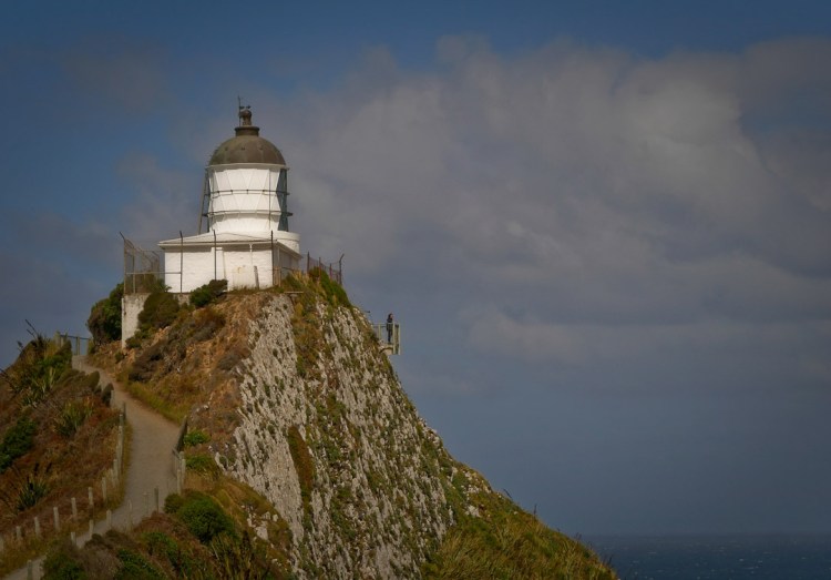
The Cathedral Caves Walk is across Maori [Kāi Tahu descent] freehold land and is managed by a trust that charges is a small fee for the use of the car park and access to the bush track, beach and caves, during low tide only, in-between late October [spring tides may delay the opening a few weeks] and May..

Cathedral Caves Walk, Catlins, NZ

Cathedral Caves Walk, Catlins, NZ
Cathedral Caves are located in cliffs at the northern end of the Waipati Beach. Two sea-formed passages together measure just on 200 metres, with a height measuring up to 30 metres! Access is by a 1km walking track that descends through podocarp and kamahi coastal forest of the Waipati Beach Scenic Reserve. Upon reaching the beach, it’s a 10 minute walk to the Caves.

Cathedral Caves Walk, Catlins, NZ

The walk to the caves was really enjoyable, but all too soon it was time drive further south…

Stinkhorn, and flies attracted the rotten meat smell emitted from this plallus shaped fungi…
Stinkhorn fungi and flies, Catlins, Otago, NZ

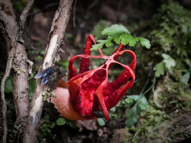
Maybe not good to meet if you’re in bare feet enjoying the beach…
Crab, Catlins, Otago, NZ

I’ve never seen a spoonbill feed before and was rather amazed to observe them swinging their upper body through 180 degree while their beak is in the water – presumably it sort of sifts what passes through, or over the tongue…
Spoonbill feeding, Catlins, Otago, NZ

Red bill gulls resting…
Red bill gulls, Catlins, Otago, NZ

On the Mclean Falls track...
Podocarp Bush, Catlins, Otago, NZ

Mclean Falls…
Mcleans waterfall, Catlins, Otago, NZ

Mclean Falls again…
Mcleans waterfall, Catlins, Otago, NZ

One more article [#3 of 3] to come about this region – the images are prepared and I hope to write up 300 words + in the next week.

Read Part 1 here >>

Exploring the Catlins – New Zealanders playing as tourists – part 1

While composing the first of three posts [too many photos for one] on this southern Otago coast-line what comes to mind is shipwrecks! This, because of spending an hour or two in the museum at Owaka, and if I recall correctly there have been dozens of them [an on-line search will easily bring up the major 20 or so].

Maybe this emphasis on shipwrecks has been a marketing ploy to increase a sense of romantic associations with drama and the sea, but I note “The Catlins” were named after the whaler Captain Edward Cattlin, and that the region supported four whaling stations at one time.
Cattlin apparently purchased some land from chief Hone Tuhawaiki of the Māori Ngāi Tahu in 1840. The sale however was not endorsed by the relevant government agency/inquiry into the validity of claims land purchased by settlers from the Māori prior to 1840.
The main town relatively close to Dunedin is Owaka, which in Māori means “place of canoes”.

Never a truer word spoken – OK well, written on the well trodden path to the famous Nugget Point / Ka Tokata Lighthouse…
Catlins coastline interp board

It’s hard to get just one lone tourist, but if patient…
Nugget Point Lighthouse

Some of the rocks that are the bane of seafarers..
Nugget Point, Catlins

No place to be in the water! A gull, one of three species all endangered in NZ, makes play of the strong southerly pushing up the sea…
Nugget Point rocks and surf with a gull

Dusk and mist settle on the Catlins River estuary…
Catlins Estuary

Podocarp forest wind ravaged…
Catlins Estuary trees flagging

Sunset with sea mist…
Catlins Estuary sunset

Tides out..
Catlins Estuary sand patterns

I’ve never seen tui feeding on what lives on the seashore. It’s also one of the thinnest tui I’ve ever seen. Not sure if there is a lesson in this…
Catlins Estuary tui feeding

Wherever you wander in this area it’s wise to keep your eyes open, and when two lovers are spotted give them a wide birth of 20 meters or more. One of them is probably in pup, and at some point she’ll leave this bohemian setting and head inland into the podocarp forest to hide from the males – yes they can move surprisingly rapidly, and while there I saw one make quick work of scaling a vertical meter high bank…
Catlins Estuary sea lions

Purakaunui Falls – likes millions before us, they have to be seen. Personally they were much smaller than I was expecting…
Catlins waterfall

One more article to come about this region – the images are prepared and I hope to write up 300 words + in the next week.

See Part 2 here >>