Braided River Bird Monitoring – how it works

Braided rivers are a common in Alaska, Canada, New Zealand’s South Island, and the Himalayas, which all contain young, rapidly eroding mountains. They are a unique environment inhabited by equally unique birds.

They simply cannot contain a river in a straight line. In floods especially they carry sediment, and in places where the flow slows down this settles on the bottom, thus raising it. And the water flows off to the side of least resistance. This will happen constantly during floods.

The technique for gathering bird numbers on these sort of rivers is quite simple: a team of four people spread out, in radio contact with each other, walk downstream counting every bird they see in front of them. On the ground or airborne.

And at that point the simplicity vanishes! Very finely tuned river crossing skills are needed, as well as “an eye” for the line that will give the best results. Plus physical stamina.

The tools of the trade are: a radio each, walking pole to aid crossings, binoculars, sun-cream, sun hat, good boots and gaiters [to stop gravels getting in the socks], GPS each, and a pen/paper/clipboard. Plus lunch, warm clothing, a camera etc. Warm dry socks also help at the end of the day.

A view upstream of the Hunter River that feeds Lake Hawea in Otago, New Zealand
Preparation. In this case to get into the very remote Hunter Valley. In the Wanaka area two other rivers, the Matukituki and Makarora are also done, and they don’t require a helicopter drop in. There is 25 years now of history – each river being monitored every third year.

The three year cycle is sometimes hard to maintain. The work has to be done in the spring when the birds are breeding, and this is when there is a high frequency of floods, with high levels due to snow melt.
After a short but steep climb in the helicopter from Makarora town-ship, on popping over the ridge the large and rugged Mckerrow Range come into full panoramic view [actually named after a close friend’s grandfather who did lots of surveying and exploring.
Dropping the over-night gear off by a hut, before flying further up the valley to begin the survey.
On the left [note the silt in the grass!] where we only go to avoid a complex river crossing; and where we do – the gravel on the right.
One species of many that we’re looking for. The ‎nationally vulnerable banded dotterel / tūturiwhatu, is the most common small plover of New Zealand seashores, estuaries and riverbeds.

This one is feigning a broken wing to lead the surveyor/photographer away from a nest.

After breeding, they either remain at the nesting area or move relatively short distances to nearby estuaries.
Typical nesting surface, and one of the team striding it out. Being very careful to not stand on eggs!
On the wing. A black fronted tern. Not in the Hunter though, but the Tasman River near Mt Cook. The blue colouring of the very cold water is caused by rock ground up by glaciers.

There are about six species that are primarily dependent on the braided river habitat: wrybill, banded dotterel, south island pied oyster-catcher, black-fronted tern, black-billed gull, black stilt) as well as the caspian tern and the pied stilt. The villain of the piece though is the black-back gull, as they predate on the eggs of the others.

Teaming up – linking arms for mutual support. Lots of concentration is required so it’s harder to observe what maybe in the air ahead. However the most experienced person leading the crossing, which is nearly done, has in this instance time to look. River crossing is best done by not looking down, which upsets balance, and with great care – there is no Plan B if people get swept away.
When not to cross at all – just too big and not braided into smaller channels.
The job is going well!
What we don’t want to see, but if we do, weeds are recorded as Way Points on a GPS, so that DOC staff can return later to deal to them. The most often encountered on the above mentioned rivers is this area, is often broom.

We don’t encounter many lupins in the above mentioned rivers. This photo is in the nearby Ahuriri. Lupins, which the birds don’t like, offer cover to predators. Foolishly seeds were spread many decades ago by well meaning people wanting to add some colour to the grey landscape. And the seeds can remain for years until uncovered by a flood as they’re coated with a protective oil.
A sad aspect of some surveys is that we know that after a bank-to-bank spring flood hundreds of these young birds are washed away. These are a few surviving gulls after such an event in the Matukituki a few years back.
Knock off time – a classic old-time hut.
Every hut has one
Evening and time for sleep. Tomorrow morning the survey will resume tidying up the riverbed to the right.
Job over and pickup
The long and sometimes bumpy drive home beside Lake Hawea

Obviously the results of such monitoring give a good guide as to the health of the environments concerned.

However the data as regards where breeding colonies are located, can be used for the most efficient locations for a new trapping lines. There is an attrition of traps though – during floods despite them being anchored by a chain to a long steel stake hammered in, they get washed away. Often the best compromise often considered, is for them to be near a bank that exhibits a history of stability, and place them with a shorter distance apart than the 200 mt standard in the bush, so as to create a fence of sorts.

The great New Zealand lupin debate and why it matters

First we need to talk about the lupin’s favoured environment being mainily the braided rivers which drain the Southern Alps – rivers that find it impossible to run in a straight line, and be anything other than dynamic.

When in flood braided rivers carry sediment from the ever rising mountains [geologically speaking] and landslides that frequent such a young country, and at every point where the water flow slows down the carried sediment settles onto the bed of the river, thus in time raising the level of same, and the river, seeking always the path of least resistance, flows off to the side. Thus during high water levels and floods the nature of this predominately gravel environment can change in several hours

The Hunter River that flows into Lake Hawea…
Hunter River


The delightful, endemic and endangered NZ banded dotterel / tuturiwhatu is one of many birds that has evolved to breed in these river beds. Despite exhibiting a variety of seasonal movement patterns ranging from sedentary behaviour, through migration within New Zealand, to trans-Tasman migration, it is hard to not love their comical stop-start actions…
Banded Dotterel


This is typical tuturiwhatu breeding ground – also shared with wrybill and other like minded birds. OK to us humans it is pretty desolate, but keep in mind it lets them see any predators, and when they do they mimic an injury to lure rats, cats and stoats away from off-spring…
Riverbeds 2


Well meaning flower lovers of decades ago decided to brighten up the desolation, and spread the non native lupin seed. They probably never realised the above, and that each seed being coated with a type of oil to preserve it, can survive for several years sprouting only when ideal conditions exist. The perfect seed for such a dynamic bed – they of course then become impossible to get rid of, apart from annual spraying and that is not a cunning or cheap thing to do in waterways annually…
Lupins in The Ahuriri river valley


And then there are wilding pines – these ones have been sprayed. The terrain hosting cushion type vegetation is again the sort chosen for nesting…
Tasman Riverbed


No one denies the lupins look beautiful. And by-the-way after the brief flowering is over they become anything but ethereal, and more of an eyesore…
Lupins in The Ahuriri river valley


Another beautiful frequenter of the braided river environment is the black fronted tern tarapirohe. They spend hours swooping for bugs above and on the glacial silt laden blue/grey water surface, and of course breed nearby…
Tern


The natural state as another dawn breaks on a braided river in The Southern Alps…
Tasman Riverbed dawn light


If only lupins could be confined to roadsides! But even in such a place they invite suicide by flowery eyed tourists, toting cameras that are scant protection against the 110km/hr traffic that rushes by their nearby vehicles, the parking of which is more spontaneous than well thought out…
Lupins again


The two villains together on the shores of Lake Pukaki…
Lupins and a wilding pine - Lake Pukaki


The uniquely billed wrybill / ngutuparore which breeds only in braided rivers of the South Island. It is the only bird in the world with a laterally-curved bill [curved to the right], which it uses to reach insect larvae under rounded riverbed stones. Wrybills are completely dependent on the greywacke shingle of the riverbeds…
Wry bill


Saving the critically threatened southern New Zealand dotterel

Rachel Hufton of Illuminate Ecology, reports following a cannon netting bird banding trip at Awarua Bay, Invercargill, an important wintering site for the South Island New Zealand dotterel. A Nationally Critical Threatened Species of conservation concern.

South Island Dotterel

above: South Island dotterel with South Island pied oystercatcher and a bar-tailed godwit at high tide roost site, Awarua Bay, Invercargill

The New Zealand dotterel is an endemic shorebird which was once widespread throughout NZ until the late 19th Century. Since then it has seriously declined in range and numbers and is now found in two distinct breeding populations. The two sub-species were first recognised in 1994; the North Island dotterel Charadrius obscurus aquilonius (Nationally Vulnerable) and the South Island Dotterel Charadrius obscurus obscurus (Nationally Critical).

The northern dotterel is more numerous, found on or near to the coast (mainly on the shores of the Eastern North Island). The southern dotterel was widespread but now only breeds on Stewart Island wintering here at the coast or at Awarua Bay in Invercargill (a popular wintering site for shorebirds) feeding on intertidal mudflats. It is generally a larger bird, with a heavier build than the northern dotterel and tends to be darker in colouration. Biometric measurements for bird (e.g. mid-toe) and egg are also different.

South Island Dotterel


South Island Dotterel

above: South Island dotterel Awarau Bay in breeding plumage and returning to basic plumage – Photography credit for both above Glenda Rees

The breeding habitat of the New Zealand dotterel is the most defining difference between the two sub-species. The North Island dotterel nests within an impression on beaches where as the South Island dotterel is more terrestrial nesting in the herb rich hills of Stewart Island, above the tree-line.

The population of South Island dotterel sub-species was at its lowest 25 years ago at 62 birds. Since then, considerable efforts targeting pest control have increased the population. The current population is now around 153 individuals. This is a decline from previous recovered population of 290 in 2009 as a result of a targeted cat (feral) control regime. This was however no longer solely effective and the population fell to 126 birds in 2016. The population appears to fluctuate and a slight increase is to be treated with caution as these birds are potentially at risk of extinction, especially in relation to further threats now identified by the NZ Dept. of Conservation (DOC) (highlighted below).

DOC Trail cameras installed at nest sites on Stewart Island have identified further threats to this critically vulnerable species such as the Australasian harrier, spur-wing plover and white-tailed deer, which have been observed taking eggs from nest sites. Accumulative threats have also resulted in a sex ratio imbalance, as males have been found to incubate eggs at night and therefore more susceptible to predation.

In light of historical population trends, DOC are now actively developing further conservation action planning for the South Island sub-species. This forms a ramp up on invasive predator control including new toxin targeted at cats, rat control, variety of kill traps and control of other predator species such as spur-winged plover. There will be active nest surveillance, cameras installed and field monitoring rangers. Further birds will also be colour banded to help monitor adult survival, abundance, site fidelity and to screen for disease such as avian malaria.

This work has started, and on 6 June 2017 additional South Island dotterels were captured at one of their wintering sites, Awarua Bay, Invercargill by a OSNZ cannon netting team working alongside DOC Invercargill. Below shows the cannon netting site set up where birds roost during high tide.

South Island Dotterel Cannon netting

above: Cannon netting site at Awarua Bay, Invercargill at low tide.

All birds (adults and juveniles) were colour banded, processed and screened to help provide a better understanding, aid monitoring and guide conservation management of this species. Colour bands provide a unique identification code and allow birds to be identified and monitored more easily in the field (*no birds were injured or harmed during cannon netting).

South Island Dotterel

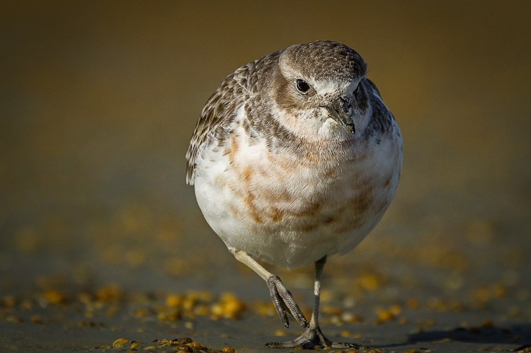
above: Adult South Island dotterel with unique colour band identification. Note: wide bill, large eye and pale legs. High tide roost site in the background with bird observation optics

This article highlights the importance of species population monitoring to guide effective conservation management. With concentrated efforts in place from a broad alliance of conservationists, there is hope of saving this endemic New Zealand shorebird for future generations.

References
Images by Rachel Hufton and where stated Glenda Rees.

Carter, K (2017). Saving the Southern New Zealand Dotterel. Department of Conservation. Stewart Island. Presentation given at the OSNZ Conference Te Anau, June 2017.

Dowding, J, E (1994). Morphometrics and Ecology of the New Zealand Dotterel Charadrius obscurus with a description of a new sub-species. Notornis. Vol 1. Part 4.

http://nzbirdsonline.org.nz/species/new-zealand-dotterel