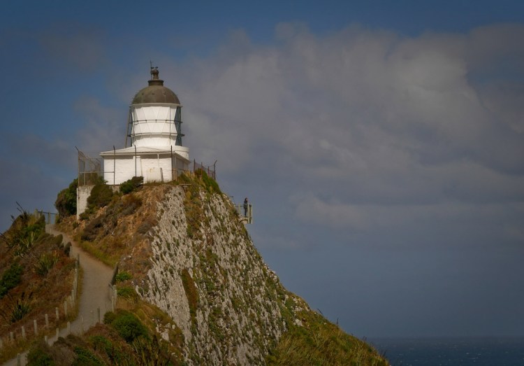
Exploring the Catlins – New Zealanders playing as tourists – part 2

Prior to this five day trip down the length of the coastline south of Dunedin known as the Catlins, my knowledge was limited to widely spaced out experiences such as an outdoor first aid course at the largest town Osaka, a school trip to a camp at Pounawea, a marvellous tramping and bushcraft training trip onto and along the Wapati Beach [at the end of which lurks the huge Cathedral caves, and we’d not had time to get to them], and much more recently assisting with road surveying at the southern end of the area in the vicinity of Curio Bay.

Well you may think that all the above words summarise “the Catlins”, but no, in-between is a wealth of interesting areas steeped in a history rich in seafaring endeavours, waterfalls, caves, timber milling and farming. Now days tourism especially in the summer “season” is a big thing though.

This “fill in the gaps”, scoping the flora and fauna trip for me bought up a lot of feelings I found fascinating. Maybe there is little outright poverty in this area that hosts something like a hundred or two rainy days a year, but under the hood of the vibrant summer tourism season, just getting underway there was evidence of a hand-to-mouth existence not easily found where I live in Wanaka.

As the trip unfolded it was great to see few tourism operations that exhibited  a shallowness, and come across museums, cafes etc. and people that were real, what I call, Kiwi’ana.

The Cathedral Caves Walk is across Maori [Kāi Tahu descent] freehold land and is managed by a trust that charges is a small fee for the use of the car park and access to the bush track, beach and caves, during low tide only, in-between late October [spring tides may delay the opening a few weeks] and May..

Cathedral Caves Walk, Catlins, NZ

Cathedral Caves Walk, Catlins, NZ
Cathedral Caves are located in cliffs at the northern end of the Waipati Beach. Two sea-formed passages together measure just on 200 metres, with a height measuring up to 30 metres! Access is by a 1km walking track that descends through podocarp and kamahi coastal forest of the Waipati Beach Scenic Reserve. Upon reaching the beach, it’s a 10 minute walk to the Caves.

Cathedral Caves Walk, Catlins, NZ

The walk to the caves was really enjoyable, but all too soon it was time drive further south…

Stinkhorn, and flies attracted the rotten meat smell emitted from this plallus shaped fungi…
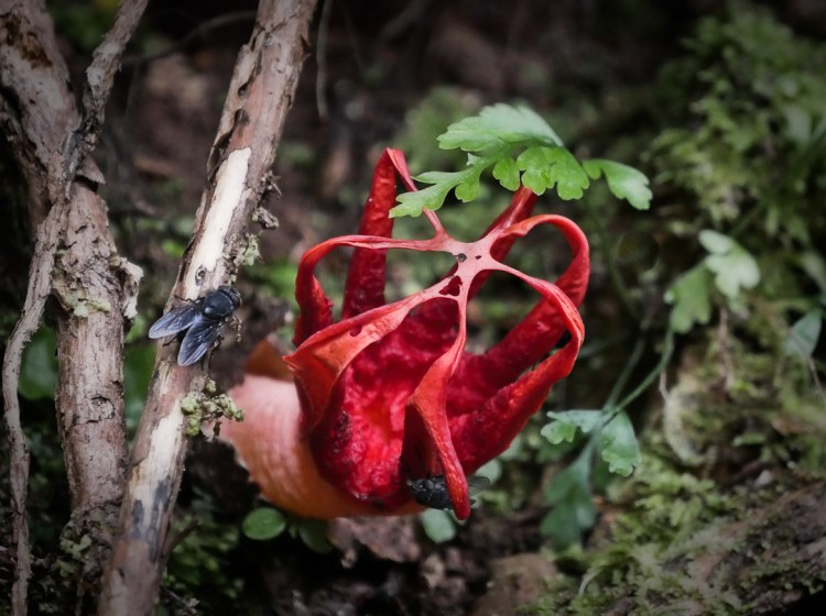
Stinkhorn fungi and flies, Catlins, Otago, NZ

Maybe not good to meet if you’re in bare feet enjoying the beach…
Crab, Catlins, Otago, NZ

I’ve never seen a spoonbill feed before and was rather amazed to observe them swinging their upper body through 180 degree while their beak is in the water – presumably it sort of sifts what passes through, or over the tongue…
Spoonbill feeding, Catlins, Otago, NZ

Red bill gulls resting…
Red bill gulls, Catlins, Otago, NZ

On the Mclean Falls track...
Podocarp Bush, Catlins, Otago, NZ

Mclean Falls…
Mcleans waterfall, Catlins, Otago, NZ

Mclean Falls again…
Mcleans waterfall, Catlins, Otago, NZ

One more article [#3 of 3] to come about this region – the images are prepared and I hope to write up 300 words + in the next week.

Read Part 1 here >>

Exploring the Catlins – New Zealanders playing as tourists – part 1

While composing the first of three posts [too many photos for one] on this southern Otago coast-line what comes to mind is shipwrecks! This, because of spending an hour or two in the museum at Owaka, and if I recall correctly there have been dozens of them [an on-line search will easily bring up the major 20 or so].

Maybe this emphasis on shipwrecks has been a marketing ploy to increase a sense of romantic associations with drama and the sea, but I note “The Catlins” were named after the whaler Captain Edward Cattlin, and that the region supported four whaling stations at one time.
Cattlin apparently purchased some land from chief Hone Tuhawaiki of the Māori Ngāi Tahu in 1840. The sale however was not endorsed by the relevant government agency/inquiry into the validity of claims land purchased by settlers from the Māori prior to 1840.
The main town relatively close to Dunedin is Owaka, which in Māori means “place of canoes”.

Never a truer word spoken – OK well, written on the well trodden path to the famous Nugget Point / Ka Tokata Lighthouse…
Catlins coastline interp board

It’s hard to get just one lone tourist, but if patient…
Nugget Point Lighthouse

Some of the rocks that are the bane of seafarers..
Nugget Point, Catlins

No place to be in the water! A gull, one of three species all endangered in NZ, makes play of the strong southerly pushing up the sea…
Nugget Point rocks and surf with a gull

Dusk and mist settle on the Catlins River estuary…
Catlins Estuary

Podocarp forest wind ravaged…
Catlins Estuary trees flagging

Sunset with sea mist…
Catlins Estuary sunset

Tides out..
Catlins Estuary sand patterns

I’ve never seen tui feeding on what lives on the seashore. It’s also one of the thinnest tui I’ve ever seen. Not sure if there is a lesson in this…
Catlins Estuary tui feeding

Wherever you wander in this area it’s wise to keep your eyes open, and when two lovers are spotted give them a wide birth of 20 meters or more. One of them is probably in pup, and at some point she’ll leave this bohemian setting and head inland into the podocarp forest to hide from the males – yes they can move surprisingly rapidly, and while there I saw one make quick work of scaling a vertical meter high bank…
Catlins Estuary sea lions

Purakaunui Falls – likes millions before us, they have to be seen. Personally they were much smaller than I was expecting…
Catlins waterfall

One more article to come about this region – the images are prepared and I hope to write up 300 words + in the next week.

See Part 2 here >>

In reply to a recent article (“Is our water quality testing of Lake Hawea proactive enough?”)

In reply to a recent article (“Is our water quality testing of Lake Hawea proactive enough?”), the Guardians of Lake Hawea would like to reassure readers that the change in lake colour this summer is not due to an algal bloom.

The change from clear to bright or milky blue is caused by an influx of sediment from the lake’s major tributary, the Hunter River, at the head of the lake (photos 1 & 2).

Photo 1:  Lake Hawea adjacent to the Hunter River delta on March 10 2018.  Delta of Big Hopwood Burn visible near top of picture. The water is discoloured with sediment near the river mouth. Trevor Chinn photo.
chinn-photo-1.png


Photo 2: The lower Hunter River on March 10 2018. The water is milky with sediment. Delta of the High Burn at lower left of the picture. Trevor Chinn photo.
Chinn photo 2


This occurred on and following 1 February with heavy rainfall from ex-tropical cyclone Fehi, and is unlikely to be related to warm summer temperatures in the Queenstown-Lakes district.

Photo 3: Flight over Lake Hawea on March 29 2018. Sediment-laden water flows from the Hunter River. Highburn Delta on left and Big Hopwood on right. John Taylor photo. Chinn photo 3


Chinn photo 4


Even if the colour does not return to clear in the near future, this is not an issue of poor water quality or the health of the lake. People who have lived near Lake Hawea for many years say that such colour changes after rainstorms have happened in the past.

So the short answer is that there should be no concern that warm weather and algal blooms have been a concern at Lake Hawea.

In the longer answer, below, the Guardians deal with some of the other questions in the article.

Is our water quality testing of Lake Hawea proactive enough?

The water quality testing is carried out by Otago Regional Council (ORC), which is currently 18 months into a “3 years out of every 10” State of the Environment Reporting Exercise. This means that the Regional Council are currently doing substantially more than they would normally be doing to monitor Lake Hawea water quality.

Following is a list of what ORC are currently doing:

On a monthly basis, samples at one site in Lake Hawea (4.5-5kms from the dam) and one site further north on a quarterly basis.

At each of these sites the following is undertaken:
Lake Hawea: Open Water “Surface” Sample

–  Sonde profiles – chlorophyll fluorescence, dissolved oxygen, pH, and temperature.

– Secchi depth (shaded side of boat with bathyscope)

–  Lake Snow tows

–  algal biomass and community  composition

– Zooplankton tow (drop net to 150m and slowly retrieve). These samples are being preserved and archived – not being analysed.

• Pooled sample from 0.5, 15, 30 and 45 metres

• Total nutrients, total dissolved nutrients and dissolved nutrients
• Total Organic Carbon / Dissolved Organic Carbon
• Chla (2 litre sample)
• Phytoplankton cell counts
• Suspended and volatile solids

Lake Hawea:  Open Water “10m” Sample

• Sample AT 10m

• Total/dissolved nutrients
• Chla (2 litre sample)
• Sonde profiles / Secchi depth

–  algal biomass only

Lake Hawea: Open Water “Deep” Sample

• Sample AT 150m

• Total/dissolved nutrients only

These samples are taken by Regional Council staff and are analysed by Watercare Laboratory, who are contracted by the Council to undertake this work.

Otago Regional Council are currently considering an increased monitoring programme for lakes Hawea, Wanaka, Wakatipu and Hayes (Otago Daily Times, April 23 2018).

Is the change in water quality only temporary?

Yes, water clarity will recover when sediments settle out and or flow through the lake. Another event like this has occurred on Lake Wakatipu, where the whole lake (right down to Kingston) changed colour in January 2014 after a massive landslide into the Dart River. The upper part of Lake Wakatipu is still cloudy when the Dart River floods, but much of the lake is clear much of the time

If the lake water clarity does return to normal, will the deterioration be repeated with increased hot weather spells in future summers?

As the cloudiness of the water is caused by sediment, any future hot weather should have no effect. The lake water clarity will be continue to be impacted by heavy rain (as at Lake Wakatipu).

Are our current tolerances of nitrogen levels within the lake too high given the probable increase in mean summer water temperatures resulting in risk to further and perhaps more serious algal blooms?

There have not been any “serious algal blooms”. Lake Hawea nutrients (nitrates and phosphates) are shown by ORC sampling to be very low.  Phosphorus is at the limits of detection and total nitrates are only around 0.06mg/litre, with ammonium nitrogen around 0.005mg/litre.

In fact, the small cyanobacteria observed are some of the primary producers in the lake ecosystem – like the grass at the bottom of the food chain. They are not the larger forms such as Phormidium, which occur in warmer and more nutrient-rich water, and can give rise to toxic algal mats. It is incorrect to suggest that serious or toxic algal blooms occurred in Lake Hawea in the past summer.


Jane Forsyth

Don Robertson

on behalf of Guardians of Lake Hawea

Published
Categorized as Hawea

Is our water quality testing of Lake Hawea proactive enough?

Anthony Coote, local Geo-scientist reports: 

Is our water quality testing of Lake Hawea proactive enough, and are any measured tolerances of deemed good quality appropriate, given climate change.

If you thought that Lake Hawea hasn’t looked right for about a month now, you are not alone and probably not mistaken: pale blue green in colour rather than the normal pale to dark blue. The water is not clear around the edges.

A panorama of the lake last night shows the colour change quite clearly. Of special significance is the drop off in clarity from the, milky look (unusual) in the immediate foreground, going out a few meters to where obscurity now reigns…
Lake Hawea water clarity compromised


This is how it used to look regrading colour and clarity, for years gone by…
Lake Hawea water clarity


The change appears timed with the end of the really hot weather during mid to late January with resulting increased lake water temperatures.

The poor water clarity can’t be explained by suspended mud (clay and mica mineralogy) as the lake has been low all summer with little in-flow. A sudden increase in water inflow, resulting in minimal lake level rise, in relation to the down-graded cyclone Fehi rain event took place after the change in lake water appearance. Furthermore, the lake water quality remained high all last 2016-2017 summer when high lake levels were sustained by north-westerly rain in tributary catchments.

Working on the suspicion that an algal bloom is the cause of the lake colour change, water samples were analysed under a microscope. As a possible cause to the change in lake water quality, a range of micro-organisms were identified including algae, dynoflaggellates and possible cyanobacteria. Whilst the preliminary study is only semi-quantitative, alarmingly the most abundant identified micro-organism is the possible cyanobacteria, the “blooming” of which is mostly likely to cause the current lake water discolouration.

The questions are:

Is the change in water quality only temporary and that it will revert to normal conditions once water temperature stratification is lost resulting in termination of the algal bloom (assuming it is the cause)?

If the lake water clarity does return to normal, will the deterioration be repeated with increased hot weather spells in future summers?

Are our current tolerances of nitrogen levels within the lake too high given the probable increase in mean summer water temperatures resulting in risk to further and perhaps more serious algal blooms.

Anthony Coote MSc (1st Class Hons) MBA, member AIG & SEG
Hawea kiteing
Lake Hawea kite surfer

Read a reply to the above by the Guardians of Lake Hawea ~ dated 11 May 2018 >>

Makarora Braided River – an under estimated biodiversity hotspot

Makarora braided river approaching the head of Lake Wanaka. BRaid (2017).

From the headwaters of the Makarora on the eastern flanks of the Southern Alps near the Haast Pass in Mt Aspiring National Park. The Makarora River flows south west and is joined by the Blue and the Young Rivers, then extending its braid plain further meeting its confluence with the Wilkin River before dissipating its energy into the head of Lake Wanaka.

Driving along the Wanaka Haast highway the Makarora braided river habitat is often overlooked or missed totally, yet the Makarora River is quite spectacular and is an important habitat for a number of important endemic New Zealand bird species and an array of other flora and fauna. A section of this captivating landscape can be seen in the video footage https://www.youtube.com/watch?v=g242GDSweiA produced by Braided River Aid (BRaid) on a frosty July morning. Braided rivers (defined by migrating, weaving channels of water between temporary islands of gravel) are iconic habitats unique to New Zealand encompassing an array of wildlife found nowhere else in the world.

There are a number of endemic bird species which depend on this habitat to complete their breeding cycle. During spring, braided river birds such as wrybill, black-fronted tern and black-billed gull can be seen returning to their breeding sites within the South Island.

The wrybill or ngutuparore is the only bird in the world that has a specialised bill which bends to the right, allowing it to feed beneath boulders and along the surface of the water on biofilm. This charismatic grey plover is nationally vulnerable relying on the unique braided river habitat to maintain its life cycle.


Adult wrybill nesting within braided riverbed (OSNZ courtesy of Dianne Parker).

Here the wrybill nests, lays eggs and rears chicks, its cryptic colouration blended effortlessly amongst the alluvial gravels of the riverbed. From January, onward wrybill flocks migrate north to their wintering grounds mainly in the Manakau and the Firth of Thames with smaller flocks elsewhere.

Juvenile wrybill at Miranda chenir shell bank (Firth of Thames) wintering site. Rachel Hufton

The black-fronted tern or tarapirohe, nationally endangered, is an attractive and highly distinctive bird in breeding plumage, slate grey contrasting with a black cap and bright orange bill and legs. Black-fronted terns also breed only on braided riverbeds of the eastern and southern South Island, from Marlborough to the Southland within small colonies and have now returned to Makarora. Their eggs and chicks are also well camouflaged against braided river gravels.


Black-fronted tern roost on a gravel island at Makarora. Rachel Hufton.

The black-billed gull or tarapuka is the most threatened gull species in the world. Though still relatively abundant, numbers of birds throughout the South Island have rapidly declined. The black-billed gull is more slender than the red-billed gull, with a longer bill and nests in colonies mainly on sparsely vegetated gravel riverbeds.


Black-billed gull colony on the Makarora braided river. Rachel Hufton.

Other braided river birds present on the Makarora include banded dotterel and South Island pied oystercatcher. The banded dotterel is the most common small plover of New Zealand coasts, estuaries and riverbeds but is nationally vulnerable. Banded dotterel breed within the braided river habitat but also use other habitats for nesting. Often seen running along the waters edge whilst foraging for invertebrates.

The South Island pied oystercatcher is the most abundant oystercatcher in New Zealand but is declining nationally. Pairs of South Island oystercatchers are often seen breeding in braided river beds but also within adjacent farmland. The conspicuous black and white plumage, distinct call and long red bill make this a familiar species.

Braided rivers are dynamic habitats, and as a result are threatened by a wide range of factors. These include habitat loss due to hydroelectricity development, weed encroachment of braided river breeding habitat, and recreational use of rivers. But the most significant impact is predation by introduced mammals.Black-fronted tern’s, wrybill’s and their nests are preyed on by rats, stoats, ferrets, ferral cats and hedgehogs. In addition, predation by southern black-backed gulls and Australasian swamp harriers, both of which have become more numerous following changes in landuse.

Considerable conservation management efforts have been made on some New Zealand braided river habitats, predominantly in the McKenzie Basin region and Canterbury which have positively contributed to braided river bird populations. This is evident in the Tasman Delta where Kaki black stilt have been reintroduced. A now rare species, once historically found throughout the South Island braided rivers.

The Makarora braided river requires collaborative effort to help restore, maintain and promote these specialised braided river birds to flourish for future generations worldwide. This can in part be achieved through advocacy and awareness raising. A recent braided river biodiversity and conservation workshop delivered at Makarora by a local ecologist, was a great way for students to connect with nature whilst learning about braided rivers.

Students and staff from Makarora located school camp following interactive workshop on braided river biodiversity, conservation and river safety (Andrew Shepherd).

Makarora braided river birds need help to successfully fledge their chicks this year without being subject to invasive mammalian predation from stoats, rats and hedgehogs. Any donations towards invasive mammalian trapping efforts on the Makarora braided river will be gratefully received by the threatened bird species that are beginning to nest. Donations or the sponsoring of traps can be made through the Southern Light website. With thanks.

Wrybill chick (OSNZ courtesy of Craig Mckenzie).


References

BRaid (2017) Drone video footage. Makarora and Wilkin River.

Hauer, RF. & Locke, H et al (2016). Gravel bed river floodplains are the ecological nexus of glaciated mountain landscapes. Applied Ecology. Vol 2, No 6.

nzbirdsonline.org.nz

Peat, N. Patrick, B Rebergen, A. (2016). Rivers Rare. The first 25 Years of Project River Recovery (1991 – 2016). Department of Conservation, Wellington, New Zealand.

Wittington, RJ. (2015). The foraging ecology of non-breeding wrybills (Anarhynchus frontalis) in the Firth of Thames: a thesis presented in part fulfilment of the requirements for the degree of Master of Science in Ecology at Massey University, Palmerston North, New Zealand.


Further information contact Ecologist: Rachel