Unveiling the Wonders of the 11-12 May 2024 Night Sky
The show began as soon as dusk abated!
The formation of auroras, including coronas (see below), is primarily caused by the interaction between charged particles from the solar wind and the Earth’s magnetic field. When these charged particles collide with molecules in the Earth’s atmosphere, they emit light of varying colors, creating the vibrant displays we see as auroras.
The solar wind, composed of charged particles emitted by the Sun, interacts with the Earth’s magnetosphere, which is the region around the Earth dominated by its magnetic field. This interaction causes the charged particles to follow the magnetic field lines towards the Earth’s poles. When these charged particles collide with molecules in the Earth’s atmosphere near the poles, they emit light. The colour dictated by the composition of the molecules encountered, e.g. oxygen:
Green: This is the most common aurora color, occurring at altitudes of around 100-300 kilometers when oxygen atoms are excited and emit light at a wavelength of 557.7 nanometers.
Red: This color can appear at higher altitudes (above 300 kilometers) when oxygen atoms emit light at a wavelength of 630.0 nanometers.
The lower green portion is known as dunes (because presumably they resemble same!)
Around 8-9 pm the display became very dynamic and changed by the minute. This is how it appeared due south.
And then it changed arching from east, to west (as per this image).
And then everything got very surprising! An auroral corona appeared directly overhead.
A corona occurs when the aurora borealis (in the Northern Hemisphere) or aurora australis (in the Southern Hemisphere) appears directly overhead or very close to it. This phenomenon is quite rare and considered the holy grail of aurora photography due to its breathtaking beauty and rarity.
A rare phenomenon called a corona – a convergence that appeared overhead around 8.30 pm.
So, while the solar wind does indeed interact with the Earth’s magnetosphere and follow magnetic field lines towards the poles, the auroras themselves occur at high altitudes above the Earth’s surface, and the converging rays are a result of the observer’s perspective from the ground.
The camera captured some colours (as above and below) that were not obvious to me at the time. I thought I saw more of a black and white display. But I was quite busy realigning camera and tripod.
And like the whole night, changes of colour and form were constant!Not to be out-done though the solar wind offered another surprise: A STEVE
A STEVE is a type of aurora that has some distinct characteristics compared to traditional auroras.
Key Characteristics of STEVE (Strong Thermal Emission Velocity Enhancement):
Appearance:
Color: STEVE typically appears as a narrow ribbon of light that is often pinkish-purple. It can sometimes have a green component, known as the “picket fence” structure, which appears as a series of vertical green stripes.
Shape: Unlike the diffuse, curtain-like appearance of typical auroras, STEVE manifests as a sharp, narrow arc that can stretch for hundreds of kilometers across the sky.
Formation:
STEVE is formed at lower latitudes than traditional auroras, which are usually found in the auroral zones near the poles.
It is associated with subauroral ion drift (SAID), a phenomenon where fast-moving streams of charged particles move through the Earth’s magnetosphere at subauroral latitudes.
To explain ‘lower latitudes’:
STEVE typically occurs at latitudes farther from the poles and closer to the mid-latitudes. For instance, while traditional auroras (aurora borealis and aurora australis) are most commonly observed at high latitudes (e.g., around 70 degrees north or south), STEVE can be observed at somewhat lower latitudes, closer to the equator than the typical auroral zones.
Cause:
The exact cause of STEVE is still under study, but it is believed to be related to unique interactions between the Earth’s magnetosphere and solar wind, specifically involving high-energy particles and strong electric fields in the subauroral zone.
Discovery and Study:
STEVE has been observed for many years by amateur aurora watchers, but it gained significant scientific attention in recent years, leading to its formal study and categorisation.
Citizen scientists, particularly members of the Alberta Aurora Chasers group, played a crucial role in drawing attention to this phenomenon, leading to increased scientific investigation.
Differentiation from Traditional Auroras:
Altitude: Traditional auroras typically occur at altitudes of about 100-300 km, whereas STEVE can appear at slightly lower altitudes.
Location: STEVE appears in regions further away from the magnetic poles compared to where typical auroras are seen.
Physical Mechanism: While traditional auroras are caused by the collision of solar wind particles with the Earth’s atmosphere, STEVE involves a different mechanism related to ion drifts and thermal emission enhancements.
And then another phenomena…
And in the same time frame of 30 minutes, pulsing started. The analogy was like clouds forming instantaneously then vanishing moments later having apparently moved quite a distance at speeds many times great than our terrestrial based winds. There was no consistency as to direction. Of course they were not clouds, but it’s the only way I can articulate the display. Occasionally I’d have a primal reaction and flinch/duck down.
(I attempted a movie of the pulsing, but sadly my camera could not gather in enough light)
Pulsating auroras, which are a variation of the more common steady auroral displays. They are characterised by rapid fluctuations in the brightness and intensity of the auroral curtains, often resembling pulsating waves of light moving across the sky.
These pulsations indeed can occur over very short time scales, sometimes within seconds, and can give the impression of clouds forming and dissipating rapidly. The movements can be quite dynamic and unpredictable, with changes in intensity and direction occurring suddenly and without a consistent pattern.
The primal reaction I experienced, flinching or ducking down, is apparently not uncommon among observers experiencing pulsating auroras for the first time. The rapid and unpredictable nature of the pulsations can evoke a visceral response, akin to instinctual reactions to sudden changes in the environment.
The exact mechanisms behind pulsating auroras are still not fully understood, but they are thought to be related to variations in the influx of charged particles from the solar wind and fluctuations in the Earth’s magnetosphere. These variations can lead to rapid changes in the energy levels of the auroral particles, resulting in the pulsating behavior observed.
Experiencing such a dynamic and awe-inspiring natural phenomenon is truly a rare and remarkable event. My description I’m told, captures the sense of wonder and primal awe that many people feel when witnessing the beauty and power of the auroras. It’s an experience to cherish and remember for a lifetime!
Hello, here is a time lapse taken of the amazing austral auroral display on 27-28 February 2023. As seen from The Snow Farm, Cardrona Valley, New Zealand
Made out of about 180 images taken automatically over approx. 4 hour period. And for this lot I was asleep tucked up in my 4wd camper truck. I’d tied the camera tripod down and it’s weather proof up to a point. And it kept doing a 15sec exposure every 50 secs until the battery went flat.
The Importance of Protecting a Historic and Heritage Landscape in Central Otago, New Zealand
Buster Diggings is a historic gold mining site located near Naseby in Central Otago, New Zealand. The site was active from 1863 to the early 1900s and reached a population of over 700 people at its peak. The Department of Conservation (DOC) now manages the site as an Actively Conserved Historic Place and it is listed several times in the Conservation Management Strategy (CMS), a statutory legal document. Prescriptive in nature. The site is considered to be remarkably intact and of national significance, particularly for its rarity as a high-altitude, alluvial mining landscape. It is comprised of fine cream coloured auriferous-quartz gravels.
Unfortunately, the site is suffering from human impact, primarily from 4wd vehicles and motorbikes, which are driving up the sluice faces for no other reason other than pushing a vehicle to it’s limits. Thus leaving long-term wheel marks or scarring on the surface of the deposits, causing erosion.
Evidence of high risk driving and riding
Using momentum in a four wheel drive to get up a steep slope can be hazardous due to several reasons. One of the biggest hazards is the loss of control if the vehicle fails to make it to the top. In such a scenario, the momentum of the vehicle puts it in a precarious position that makes it difficult or even impossible to control the descent backwards. This can lead to serious accidents, such as a rollover, especially if the slope is steep and the surface is loose or slippery.
Additionally, over-reliance on momentum can put excessive strain on the vehicle’s drivetrain and suspension, potentially leading to mechanical failures. It’s always important to carefully assess the terrain and plan a safe and controlled ascent (or possible descent when traction becomes compromised).
Acknowledgement of the problem
DOC acknowledged this impact many years ago and erected a fence around the main sluice faces at the head of Clarks Gully in 2009. However, stronger protection measures, such as a stronger fence or the use of cameras to identify vehicle users rego (and forward to the Police), could be considered.
More than once the lock on this gate, will I daresay, have succumbed to a bullet many times.
However…
Education plays a crucial role in the success of any management program.
By educating the public, individuals are empowered to make informed decisions and take ownership of their role in achieving the desired outcome.
This approach is more effective in the long term as it creates a sense of shared responsibility and fosters a culture of sustainability.
Furthermore, educating the public also helps to build trust in the management program and its goals, as individuals are better equipped to understand the reasoning behind specific policies and actions.
Ultimately, an educational approach leads to a more engaged and invested community, resulting in greater buy-in and higher rates of success for the management program.
DOC (Department of Conservation) Interpretation Boards are an effective tool for public education as they provide information and context to the public about the local environment, conservation efforts, and the cultural and historical significance of an area. The boards can also help foster appreciation and respect for the environment, which can lead to greater support for conservation efforts.
In Conclusion
Buster Diggings is a historically significant and rare site in Central Otago, New Zealand, that is currently suffering from human impact. DOC has a responsibility to protect the site and mitigate the risks posed by 4wd vehicles and motorbikes. Stronger protection measures should be considered to preserve the site for future generations to enjoy and appreciate.
CONSERVATION MANAGEMENT STRATEGY Otago 2016
Page 51-57 on pdf: The history of the Place is protected and brought to life at the Ngāi Tahu site of Manuhaea Conservation Area at The Neck and at the Buster Diggings actively conserved historic site.
The historic Buster Diggings has to be a protected and actively managed accessible visitor site.
Why preserving Natural Beauty and Biodiversity is Important
Join me on a journey through the stunning Waikouaiti River catchment, starting in the Nenthorn area and ending at the coast at the town Waikouaiti.
For a small population someone went to a lot of trouble!
Located within the precincts of the beautiful city of Dunedin, New Zealand,. The Waikouaiti River “Mauri” offers a glimpse from the rolling high country to near the mouth of the river.
Waikouaiti River Mouth
The small town of Karitane, just 35 kilometers north of the city centre, serves as a popular holiday destination for residents of Dunedin. Come discover the beauty of the Waikouaiti River and its surrounding areas for yourself.
View of Karitane
The Journey Begins
Historic cottageMacreas is now well known for it’s vast gold mining operation. Middlemarch is very much a hub for rural farming communities.
Clearing of Native and Snow Tussock Grasses
High country lands in New Zealand have long been treasured for their unique and diverse ecosystems, which include native and snow tussock grasses. However, the conversion of these lands for agricultural purposes has resulted in the widespread clearing of these grasses. This not only destroys the habitats of native species but also destabilizes the soil, leading to soil erosion and loss of fertility.
Snow tussock grasses on the Nenthorn Conservation Area. The remains of the building probably a remnant of historic gold mining operations.
Replacement with Exotic Non-Native Tree Species
In an effort to increase productivity and profitability, many farmers have replaced native grasses with exotic non-native tree species. This has further impacted the ecosystem by reducing the biodiversity and altering the natural balance of the land.
A few minutes drive from the last photo! Wilding pines spreading to the right
Wilding Pines: A Threat to New Zealand’s High Country
Wilding pines, also known as feral pines, are a major problem in New Zealand’s high country. They quickly take over the landscape, replacing native species and reducing biodiversity. The trees form dense stands that can cover vast areas of land, shading out native vegetation and altering the natural balance of the ecosystem. In addition, their extensive root systems can make it difficult for other plants to grow and compete for resources.
The clumped nature of wilding pines also makes it difficult for people or livestock to enter areas, further reducing the potential for land use and impacting the livelihoods of those who depend on these lands. As a result, the rapid spread of wilding pines is a significant threat to the sustainability and viability of New Zealand’s high country lands. Effective management and control of wilding pines is essential to protect these unique and valuable ecosystems.
The Negative Impact of Slash from Plantation Forestry Operations on Marine Ecosystems
A major contributor to marine sediment is the harvesting activities undertaken by plantation forestry operations. In particular, the period after clear-felling, known as the “window of vulnerability,” which typically lasts around 7 years, poses a significant risk of erosion and sedimentation.
With the increasing frequency of high rainfall events caused by the global climate crisis, steep land that has recently been harvested is more susceptible to landslides and erosion. The resulting sediment runoff can have devastating effects on the marine environment, smothering aquatic life and altering the delicate balance of the ecosystem.
In the Marlborough Sounds, this pollution is leading to significant adverse impacts on marine flora and fauna. The accumulation of slash, or the branches left to rot after harvesting, is a prime example of the short-sighted practices that are causing harm to the environment. The slash acts as a source of sediment during high rainfall events, contributing to the degradation of marine habitats and the decline of marine species. It is crucial that we take steps to mitigate the negative impact of slash from plantation forestry operations on marine ecosystems. This includes proper management of harvesting activities, implementation of best practices to reduce sediment runoff, and investment in research and development to find sustainable solutions.
Loss of the Blotting Paper Effect
Native grasses severely degraded from waist high/several centuries old. With a backdrop of rural European style development. Nenthorn Conservation Area behind the photographer (myself).
The conversion of high country lands for agriculture has reduced their ability to absorb and retain water, causing soil loss and sedimentation in rivers. With increasing conversion at altitude, native vegetation regeneration is virtually non-existent.
Even more contrasts. Bare ground, cattle, cropping and sheep. With native tussocks on the road side.If the terrain is at the limit of what a tractor can traverse, then in terms of rain water run off, it’s too steep. There will be severe downstream effects during floods.
Introduction of Cattle and Sheep Grazing
The introduction of cattle and sheep grazing has also had a significant impact on the high country lands. These animals consume large amounts of vegetation, causing soil erosion and degradation of the land. They also trample the soil and compact it, reducing its ability to retain water and nutrients.
Snow tussock area being cleared just a little east of the Nenthorn Conservation Area. Fertiliser trucks spreading… Presumably for planned pasture for stock.
Detrimental Effect on Marine Species
The soil erosion and sedimentation of rivers have had a detrimental effect on marine species near the coastline, including penguin populations. The sediment clouds the water, reducing the amount of light that reaches the ocean floor and impacting the health of marine plants and animals. Additionally, the increased nutrients from fertilisers can lead to harmful algal blooms, which can have toxic effects on marine life.
The Waikouaiti River flooding 2022. The access bridge to Karitane to the right. Taken very close to the fine weather photo above of a fishing boat. Photo courtesy the Internet.Driving through the town of Waikouaiti 2018. Sediment is evident. From nearby creeks, and is typical of what washes down all the way from Nenthorn. Water supply tests in 2020 revealed concerning levels of lead in the town’s water supply (now fixed). Problems abound and compound on all fronts!
In conclusion
The conversion of New Zealand’s high country lands for agricultural purposes has had numerous negative effects on the ecosystem. From the clearing of native grasses and introduction of exotic non-native tree species, to the loss of the blotting paper effect and the impact on marine species, it is clear that the sustainability of these lands should be a top priority.
Honouring the native and indigenous status quo is a much better outcome for all concerned!
The story of the Matukituki Charitable Trust. Mt Aspiring National Park
An explanation of the relationship between biodiversity and trapping predators
This rather long post was put together originally as an evening talk on trapping to the Wanaka Vegetable Growers Club. It went down so well that I’ve now two more to give. And having assembled the photos it made sense to publish them here.
Before we get to the Matukituki Charitable Trust in Mt Aspiring National Park, lets look at different environments and how they differ in their own unique ways.
A typical braided river – The Hunter that flows into Lake Hawea, and some of the locals…
Black bill gulls. Homeless after a severe bank-to-bank flood. Thousands of their peers would have been washed away. And a banded dotterel playing at being injured to lure the photographer away.
Doing a braided river bird survey takes at least 4 very fit people. Who not only know their birds in spring time, but are also very capable at crossing the braids of the river concerned (occasionally grouping up for some serious crossings). They fan out mostly, in radio contact, and record everything they see in front of them as they walk downstream. Good weather essential.
Typical nesting terrain. But not a place suitable for trap placement.When lupins invade. Not only do they not suit breeding habits developed over countless centuries, they provide predators with cover and shelter/warmth.
Moving on to another environment…
A remote area between Lake Hawea and Tarras to the east, is host to the endangered Grand and Otago skinks…
To flood prone/dynamic for the birds.
Away from the Southern Alps a bit, it’s much drier.
This requires a different trapping regime, e.g. rings of traps placed around very steep bluffs, targeting mostly opossums and hedgehogs. Recently about 80 skinks were captured and relocated to safer managed areas in Otago, such as Macraes.
Now on with the real story…
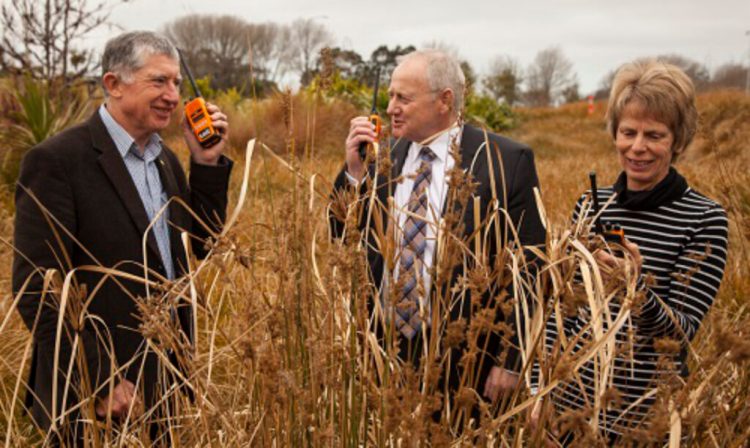
The Matukituki Charitable Trust was set up in 2013 by Derek and Gillian Crombie, who are the founding Trustees. A partnership was entered into with DOC’s Wanaka Area Office Manager, Paul Hellebrekers. With the intention that it be a long-term project that would benefit species, the valley’s ecosystem and recreational users.
Photo: Derek (left) and Gillian (right) with Tait Electronics manager checking out VHF radios, donated by Taits.
Adventurer Bear Grylls and Julian Grimmond of the Mountain Film Unit in Queenstown also endorsed the project. NBC’s ‘Get Out Alive’ with Bear Grylls was filmed in the Matukituki valley in March 2013. Being enamored by the valley they donated $10,000 towards the project.
The logical base for field and trapping operations is the warden’s quarters at the historic and popular Aspiring Hut, in Mt Aspiring National Park. A facility owned by the New Zealand Alpine Club, and managed by DOC. The club readily gave the project their blessings
Photo: Two very interested local kea.
The first task was to establish which predators should be targeted!
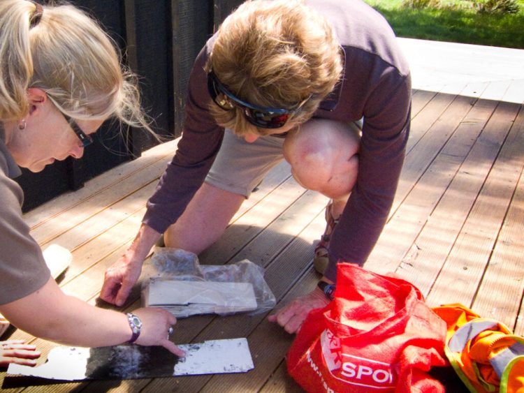
Tracking tunnels – awkward things.Inked card with footprints gathered overnight. A peanut butter blob being the enticer.
Tied down, GPS’d/ tree marker.
Some of the early days team. Left to right: Gillian, Martin (very well known Cardrona based folk singer and song writer), Flo (DOC ecologist/bio diversity), Sharon (DOC Ranger), and myself Donald (volunteer)
Along the way between installing tracking tunnels and really getting serious about “upping” the trap numbers from a couple of hundred to several hundreds, we installed a few funnels. Beech tree seedlings obligingly drop into same, and they can then be collected and counted at regular intervals. The idea being to get good data on how much food is available for predators, season to season. From this, “masting”, years of prolific seeding, can be predicted.
Other means of gathering seeds are by helicopter, or by shooting branches. With a good aim with a large gauge shotgun firing a very heavy single bullet, the correct size branch, hosting ideal clumps of seeds can be “dropped” to the ground. The shooter will usually work from a steep slope, thus shooting outwards rather than upwards.
Seriously awkward loads!An evening’s entertainment counting seedlings that were shot down – each handful typically containing about a hundred.
New Zealand falcon/kārearea with a mouse. Yes, common predator/nuisance #1 is the humble mouse. They tend to go into winter with large population numbers, and as food becomes scarce they become a means of survival and well-being for the various species of rat. Mum and dad rattus typically produce about 4 baby rats every 4-6 weeks. The less mice the better! But of course if numbers are low as the temperatures drop, the rats increasingly predate the native birds!
The real villains…
One of few species of introduced rat – photo courtesy DOC.Opossum.
Stoat – a very nasty critter Known as ermine in the northern hemisphere – note the claws, and the teeth are of similar ilk.
As mentioned above there are a few species of rattus. And they breed very fast and efficiently.
But the stoat is the real “shocker”: the father will impregnate his female off-spring. They then go off to “party up” killing for it’s own sake. And only when conditions are ideal, they’ll drop their litter. They’re increasingly migrating to higher altitudes in New Zealand also. Encouraged by climate warming for sure.
Opossum, our Australian import. They eat and destroy tons of forest canopy every night. They’re tree killers! In their home country they spend 90% of their time eating, and 10% mating. In New Zealand, thanks to the good tucker, it’s the other way round! They subsequently grow to very sizeable dimensions. Then of course need more food. Btw they will also eat eggs and fledgling birds. Their nemesis is peanut butter though.
Another nuisance is often very large gaggles of canada geese. Their poo is toxic, and they eat not quite like a horse, but certainly like a sheep or two. This throws the balance for the wading birds and ducks. The whio/blue duck being very endangered. They’re best controlled by someone riding shotgun in a helicopter (with the doors off), or by covert ground shooting with a 22. They’re surprisingly good eating, but maybe due to bad rap from farmers, no one seems to bother.
The locals that need protecting…
Kea never cease to entertain.We don’t want these lovelies to get involved with 1080!
Long tail bat habitat.We don’t want these other lovelies to get involved with 1080 either!
Rock Wren – photo courtesy DOC
South Island robins.White heron / kōtuku – not often seen, but perhaps an occasional visitor to Mt Aspiring National Park.
Tomtit. An indicator species.
The south island robin was introduced to the valley about ten years ago and a bit. Approx. a doz. birds. This small population stayed stable near Aspiring Hut for a few years, helped by about 80 traps nearby. Then in 2014 with a “leg up” from the first of three 1080 applications, the population rose steadily. Prior to this of 4 fledglings hatched to each couple each spring, only one would survive. Once trap numbers were increased from 2014 on-wards, it became obvious that in most instances all four would survive. They’ve now spread all throughout the valley, and down around the corner into the East Branch, it’s thought.
During all this time regular banding was carried out to aid monitoring. As we speak the program is being wound up and a comprehensive report is being compiled. This will be an invaluable guide as to when the next species, mohua, is relocated into the valley from a healthy colony in Fiordland.
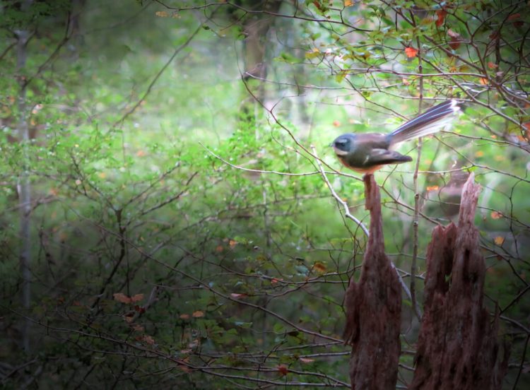
Mountain stone weta.Pīwakawaka / fantail.
Kaka.
It’s not known if the mountain stone weta exists in the valley, but the possibility exists that it maybe there. If so it can’t help but have it’s existence assured by adequate control measures.
They’re so amazing that when temperatures drop to well below zero, their whole body can freeze down to -10°C for up to 17 days. When it warms again, they thaw out and come back to life as good as new, with no cell damage!
Kākāriki / NZ parakeet. photo courtesy of Maori Point Wines.Ruru / morepork.
Kākāriki / NZ parakeet feathers
The kākāriki /NZ parakeet was the first species to reappear big-time after the program commenced in 2014. Prior to that the only evidence I came across while looking after the huts etc. was a bunch of feathers from a dead one. It had probably flown into the hut window, died, and was then eaten by the likes of a rat.
Our native owl the Ruru /morepork also reappeared not long afterwards. The one above though was mortally injured. I got it in a box, calmed it, and then carried it down valley on a Friday evening. After twenty minutes we met a DOC ranger who took it to the vet in Wanaka. But sadly it had to be euthanized the next day. There was little response to antibiotics – it’s wing was broken and maggot infested.
Their calls in the dark of the night is music to my ears. And occasionally they’d visit me. Attracted to the moths, who in turn were attracted to the hut lights. They arrive noiselessly due to their soft feathers. One night one of them sat with myself and one of my kea friends. Just hanging out enjoying the evening and each other’s company.
Ruru / morepork.Young NZ falcon / kārearea learning to hunt for mice, using hearing.
NZ falcon / kārearea.
Very happy kea.Kea capturing, for leg banding.
Juvenile kea – and no, it is quite safe, as it’s not earthed!
Kea banding and statistics work.Bellbird – it’s not a good idea to feed some species an unfamiliar and habit inducing food. e.g. kea who are habituated will then eat 1080 pellets. Currently intense on-going testing is refining ways to counteract this.
Stuffed decoy kea to attract others.
The idea behind the radio antennae is to attach a radio transmitter to female kea as it’s a very effective way to gain more knowledge when it returns to it’s nest. And hopefully also ensure fledgling survival. Often the technique is to install a trail camera in the nest, and one outside. Then surround the area with traps. Sadly the mother kea is very passive when nesting, and stoats have been shown to simply enter and help themselves.
There are an estimated 100 birds in the valley. This has probably stayed about the same from 2014 on-wards. In 2015 thirty two of them were filmed trying to vandalise a helicopter. It was shut down waiting for two people trapping to arrive for pickup. This confirmed a theory that the valley is a nursery. And like national parks world-wide; get the data and you can get the dollars (for conservation)!
About traps…
Getting into the real work! Installing and checking traps.
Fords (not the vehicle type) often change during rain events. And then need to be tidied up. Sometimes it’s very hard and time consuming work.
The serious side of biodiversity.Approaching Cascade Saddle for a people pickup.
Cascade Saddle – a new line at 1800 mts.
We worked a lot in winter in the early days.Spot the DOC 200 trap!
Extreme terrain for a new line.
Interior of an inactive DOC 200Back yard trapping enthusiast. Children unwittingly play an important role in raising awareness of bio diversity in homes.
Timms traps are simple and inexpensive but not kea proof. So they are only used down country, well away from the mountains.
The predator entry way for a DOC 200 trap, is via a hole in a grill. The attraction, or lure if you like, being an egg and a square of rabbit paste on the other side of the actual mechanism.. The cunning plan being to get the critter to cross the trigger plate. Which incidentally is so designed to not activate with the weight of a mouse. All trap types do have to pass tests to ensure they kill humanely. (an interesting word, humanely!) photos courtesy DOC
Good Nature self resetting trapNote the small entry grill on this DOC 200. So kea cannot enter!
Self resetting traps are ideal in this terrain
Dead mice below a self resetting trapNot all terrain being trapped is steep
South Island robin inspecting a DOC 200
There is ongoing research into long lasting lures for traps. Good Nature manufacturers are always testing I think. After all, for self resetting units to be useful the lure needs a reasonably long shelf life.
The tried and true lure for DOC 200s is a fresh egg (every 2-3 weeks), and some rabbit paste (see above). Tests are also underway of satellite technologies, whereby a trap sends a text message, when it has been triggered. When refined, and coupled with long lasting lures, this will cut the manual labour considerably
One of the steeper lines is up French Ridge past the hut. It starts in the shady area, and angles to the right to the snowgrass in the sunThis terrain is typical of that inhabited by rock wren. They hibernate under snow/rocks for the winter. Trap lines are not feasible in this terrain as apart for snow pack “creep”, they’d be swept away by wet snow avalanches in the spring
French Ridge hut. DOC 200s are deployed past it to the left. Over winter they’re buried by snow.
A relatively new and successful trap, known as a Trappinator. The concept is nice and simple. Later models have been modified to be more kea proof (just in case), and also have access ramps for the opossum.Several trusts have traps from Wanaka on the left, and west into head of the West Matukituki Valley. Mt Aspiring National Park
Planning trap deployment
Servicing a TrappinatorA dead stoat post a 1080 drop. It probably ate a dead mouse or rat, that had ingested the poison
This is the only feasible solution for ridding our bush of predators and vermin. It has been used in the valley on three occasions. Each time followed up by an ever increasing number of traps. This is an ideal scenario!
Much has been written already about the benefits of 1080. As a side note though several years ago more had been spent by DOC on researching it, than had been spent on actual “drops”.
After the first application of the poison in the valley in 2014, I found the dead stoat as above. In due course after I’d retrieved it, it went to Christchurch to be examined. Also simultaneously a dead opossum was covered in wire netting, and every few weeks a sample of flesh was obtained, to establish how long the poison was staying in the body. Although 100mm of rain renders the poison harmless, it can linger in dead predators. Which of course could be eaten by a dog.
At Hells Gate, the entry to the west branch of the Matukituki Valley, approx., a hundred traps span the gap seen on the left. This is to stop predators, mainly cats, hedgehogs and ferrets, from entering.
Contentment! Morning tea break for the author while trapping. And not a single sandfly in sight 🙂
Recent News from the Matukituki Charitable Trust
On Monday 19 July 2021 Nikki Holmes (Operations Manager Central Otago) DOC and MCT signed a renewal of the Matukituki Management Agreement first set up in 2015.
<< Derek Crombie (MCT) and Nikki Holmes (DOC) signing the Management Agreement
Over the last 6 or 7 years The Trust and DOC have worked together to install the 852 trap predator control network, undertake species monitoring, deliver three 1080 programmes, remove about 5,000 pests and watched as numbers of South Island Robin, Kakariki, Kaka, Bell birds, Warblers etc have thrived. This work has been carried out with an excellent working relationship and each party has assisted the other to make it a very positive project. Twice yearly meetings have been positive exchanges of information and ideas to ensure the best practice is able to be delivered.
Mohua, maybe the next phase for the Matukituki Charitable Trust. Re-location back to where they once were in the Matukituki Valley.
photo courtesy DOC.
Misc. overviews
An alternative type of trapping with ferrets and a pack of dogs.
Nets and firearms are often used with this age old combination, e.g. the ferret flushes out a rabbit, then the dogs give chase until the rabbit runs into a net made of fine mesh. Noting here also that rabbit populations attract stoats, and that when they’ve killed off the rabbits, they then target birds.
One drawback though: Dogs and National Parks don’t mix! Legislation means they’re banned. And from a common sense point of view it’s also a good idea. They can do serious damage to populations, and often the owner has no idea, and will be in denial even.
Predator Free 2050
After trials in the Jackson and Arawhata valleys prior to 2019, Zero Invasive Predators (ZIP) and DOC focused on testing the validity of using extreme terrain features as a means of stopping predators repopulating large areas where they’d been eradicated.
It was very successful! Large cold rivers, mountain ridges and glaciers are a very real deterrent.
Whataroa Valley beside the Perth. South Westland
“We’re going to nail this”
Lou Sanson, Director General of Conservation 2019. After the biggest eradication experiment held to date.
Dunedin as an example of achieving Predator Free 2050
In this blog post I’ve focused on trapping and biodiversity in terrain that is both vast, rugged and inaccessible. Around a city such as Dunedin the challenges are mainly social!
The city sees itself as NZ’s wildlife capital city. And it’s well on the way to maintaining this status. Catch phrases such as “lets get kaka back in the Octagon” have been used. Another goal I’ve heard of is aiming to have every forth household hosting a (backyard) trap. Of course education regards pet cat management will be needed.
Dunedin from Flagstaff. The Otago Peninsula, an area deemed suitable for a sanctuary is at the far left.Orokonui Ecosanctuary
The Silver Peaks, to the west behind Dunedin.
The Silver Peaks, to the west behind Dunedin, are however pretty rugged. Which will add a further challenge on top of achieving social license from the public to really ramp up control. 1080 has already been used by OSPRI, who are charged with eliminating TB that opossum carry, (and spread to cattle). Control occurred on at least two occasions and gave a wonderful “leg up” to the several trusts working at bringing back the birds.
Orokonui Ecosanctuary / Te Korowai o Mihiwaka, in the Orokonui Valley between Waitati and Pūrākaunui, 20 km to the north of central Dunedin. It has been developed and is maintained by the Otago Natural History Trust. Such successful ventures in NZ generate what is called the “halo effect”. Where the bird population increases and spills over into adjacent habitat.
The ancient one at Orokonui. There are a number of free ranging tuatara that were reintroduced in 2012.
Related good news in Otago
Macraes Mine in East Otago is NZ’s largest gold mine in opened in 2008. It is situated close to the settlement of Macraes Flat and is owned by OceanaGold Corporation.
OceanaGold have a laudable environmental program. It ranges from habitat restoration and conservation (snow grass/tussock mainly), through to skink and gecko colonies, and hosting/sponsoring a fish hatchery, maintained by Otago Fish and Game.
A last word on larger problem animals in New Zealand’s high country and National Parks
Himalayan tahr (Hemitragus jemlahicus) are large goat-like animals. Native to the central Himalayan ranges of India and Nepal, and not New Zealand. Thus they are not protected, and in fact are regarded/listed as “noxious/pests”.
photo courtesy DOC
Tahr are generally found in the alpine grassland zone, where they graze on snow tussocks, alpine herbs and sub-alpine shrub-land plants. They have no natural predators. In the fragile alpine environment they eat away the food source and shelter for the likes of rock wren and kea. It’s been estimated recently that there are 30,000 of them in the South Island high country.
Control has recently become an emotional issue. Many thinking that since legislation uses the word eradication, that this is possible. Currently it is not.
The species also supports a trophy hunting industry. Many hunters also cannot grasp that if herds reach starvation status, that trophy heads of bragging value simply won’t grow.
Good work has been done in the past by hunting associations and DOC on how to manage this animal. However the agreements reached, and work done have not been successful. Leaving management again up to DOC’s time proven methodology of shooting from helicopters.
A common question from the public, is why is the meat not retrieved. The answer is that since they inhabit very steep terrain, when shot the bodies roll and tumble considerable distances, and the meat is damaged (but kea of course can benefit from the fresh meat, especially pre winter). Also pick-up by helicopter of the carcasses is very technical and time consuming. The only feasible solution to harvesting the meat is to do the control in winter after deep snowfalls. If the cover is deep enough it slows the animals down considerably and stops the bodies rolling far.
Red deer are also listed as “noxious/pests”. Currently as of writing, populations are booming. Even in urban environments. This and a perceived right by many to hunt them for sport and food, is making control quite complex.